
Make a donation
Gear up for your next adventure:
As an Amazon Associate, this site earns from qualifying purchases at no extra cost to you.
Wells topographic map
Click on the map to display elevation.
Make a donation
Gear up for your next adventure:
As an Amazon Associate, this site earns from qualifying purchases at no extra cost to you.
Wells
Wells doesn't have a weather station, but Barkerville does (located 7 km (4.3 mi) away). Wells has a subarctic climate (Köppen climate classification Dfc), resulting in long, cold and snowy winters, accompanied by short and cool summers due to its high altitude and latitude. Its growing season averages only 66 days. It is located at the mouth of Jack of Clubs Creek, and defined as the source of the Willow River at the outflow of the Jack of Clubs Lake.
Make a donation
Gear up for your next adventure:
As an Amazon Associate, this site earns from qualifying purchases at no extra cost to you.
About this map
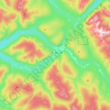
Name: Wells topographic map, elevation, terrain.
Average elevation: 4,721 ft
Minimum elevation: 3,648 ft
Maximum elevation: 6,503 ft
Make a donation
Gear up for your next adventure:
As an Amazon Associate, this site earns from qualifying purchases at no extra cost to you.
Other topographic maps
Click on a map to view its topography, its elevation and its terrain.
Interior Plateau
Canada > British Columbia > Cariboo Regional District > Area A (Red Bluff/Quesnel South)
Average elevation: 2,717 ft
Nazko Cone
Canada > British Columbia > Cariboo Regional District > Area I (West Fraser/Nazko)
Average elevation: 3,629 ft
Itcha Range
Canada > British Columbia > Cariboo Regional District > Area J (West Chilcotin)
Average elevation: 5,732 ft
Ilgachuz Range
Canada > British Columbia > Cariboo Regional District > Area J (West Chilcotin)
The Ilgachuz Range is a name given to an extinct shield volcano in British Columbia, Canada. It is not a mountain range in the normal sense, because it was formed as a single volcano that has been eroded for the past five million years. It lies on the Chilcotin Plateau, located some 350 kilometres (220 mi)…
Average elevation: 6,621 ft
Make a donation
Gear up for your next adventure:
As an Amazon Associate, this site earns from qualifying purchases at no extra cost to you.
Rainbow Range
Canada > British Columbia > Cariboo Regional District > Area J (West Chilcotin)
Average elevation: 5,712 ft
Valentine Lake
Canada > British Columbia > Cariboo Regional District > Area G (Lac La Hache/108 Mile Ranch)
Average elevation: 4,114 ft
Horsefly
Canada > British Columbia > Cariboo Regional District > Area F (Horsefly/Likely/150 Mile House)
Average elevation: 2,648 ft
Kondor Lake
Canada > British Columbia > Cariboo Regional District > Area J (West Chilcotin)
Average elevation: 5,636 ft
Make a donation
Gear up for your next adventure:
As an Amazon Associate, this site earns from qualifying purchases at no extra cost to you.
Big Creek
Canada > British Columbia > Cariboo Regional District > Area K (East Chilcotin)
Average elevation: 6,663 ft
Mount Timothy
Canada > British Columbia > Cariboo Regional District > Area G (Lac La Hache/108 Mile Ranch)
Average elevation: 4,780 ft
Anahim Lake
Canada > British Columbia > Cariboo Regional District > Area J (West Chilcotin)
Average elevation: 3,612 ft
Elbow Lake
Canada > British Columbia > Cariboo Regional District > Area F (Horsefly/Likely/150 Mile House)
Average elevation: 3,146 ft
Make a donation
Gear up for your next adventure:
As an Amazon Associate, this site earns from qualifying purchases at no extra cost to you.
Interlakes
Canada > British Columbia > Cariboo Regional District > Area L (Lone Butte/Interlakes)
Average elevation: 3,694 ft
Mount Vic
Canada > British Columbia > Cariboo Regional District > Area K (East Chilcotin)
Average elevation: 8,386 ft
Mount Juno
Canada > British Columbia > Cariboo Regional District > Area J (West Chilcotin)
Average elevation: 7,280 ft
Lac La Hache
Canada > British Columbia > Cariboo Regional District > Area G (Lac La Hache/108 Mile Ranch)
Average elevation: 2,779 ft
Make a donation
Gear up for your next adventure:
As an Amazon Associate, this site earns from qualifying purchases at no extra cost to you.
Great Canyon
Canada > British Columbia > Cariboo Regional District > Area J (West Chilcotin)
Average elevation: 4,003 ft
Antler Creek
Canada > British Columbia > Cariboo Regional District > Area C (Bowron Lake/Barlow Creek/Barkerville)
Average elevation: 3,350 ft
Map Glacier
Canada > British Columbia > Cariboo Regional District > Area J (West Chilcotin)
Average elevation: 6,683 ft
Alexis Creek
Canada > British Columbia > Cariboo Regional District > Area K (East Chilcotin)
Average elevation: 2,671 ft
Make a donation
Gear up for your next adventure:
As an Amazon Associate, this site earns from qualifying purchases at no extra cost to you.
Blue Lake
Canada > British Columbia > Cariboo Regional District > Area A (Red Bluff/Quesnel South)
Average elevation: 2,562 ft
Black Lake
Canada > British Columbia > Cariboo Regional District > Area C (Bowron Lake/Barlow Creek/Barkerville)
Average elevation: 5,594 ft
Great Canyon
Canada > British Columbia > Cariboo Regional District > Area J (West Chilcotin)
Average elevation: 4,003 ft
Whitestone Lake
Canada > British Columbia > Cariboo Regional District > Area D (Commodore Heights/McLeese Lake)
Average elevation: 2,782 ft
Make a donation
Gear up for your next adventure:
As an Amazon Associate, this site earns from qualifying purchases at no extra cost to you.
150 Mile House
Canada > British Columbia > Cariboo Regional District > Area F (Horsefly/Likely/150 Mile House)
Average elevation: 2,589 ft
Heckman Pass
Canada > British Columbia > Cariboo Regional District > Area J (West Chilcotin)
Average elevation: 4,984 ft
Lone Butte
Canada > British Columbia > Cariboo Regional District > Area L (Lone Butte/Interlakes)
The northward advance of the Pacific Great Eastern Railway (PGE) rail head passed through Lone Butte in late April 1919. This construction camp had a large kitchen employing 25 cooks, of whom two received the Distinguished Conduct Medal and three the Military Medal during World War I. At an elevation of about…
Average elevation: 3,802 ft
Twan Lake
Canada > British Columbia > Cariboo Regional District > Area K (East Chilcotin)
Average elevation: 3,087 ft
Make a donation
Gear up for your next adventure:
As an Amazon Associate, this site earns from qualifying purchases at no extra cost to you.
Horse Lake
Canada > British Columbia > Cariboo Regional District > Area K (East Chilcotin)
Average elevation: 6,358 ft
Bouchie Lake
Canada > British Columbia > Cariboo Regional District > Area B (Quesnel West/Bouchie Lake)
Average elevation: 2,293 ft
Cottonwood River
Canada > British Columbia > Cariboo Regional District > Area C (Bowron Lake/Barlow Creek/Barkerville)
Average elevation: 2,621 ft
Barkerville
Canada > British Columbia > Cariboo Regional District > Area C (Bowron Lake/Barlow Creek/Barkerville)
Barkerville has a subarctic climate (Köppen climate classification Dfc), which makes it have long, cold and snowy winter and short and cool summers due to its high altitude and latitude. Its growing season averages only 66 days.
Average elevation: 4,708 ft
Make a donation
Gear up for your next adventure:
As an Amazon Associate, this site earns from qualifying purchases at no extra cost to you.
Deka Lake
Canada > British Columbia > Cariboo Regional District > Area L (Lone Butte/Interlakes)
Average elevation: 3,743 ft
Williams Lake
Canada > British Columbia > Cariboo Regional District > Williams Lake
Average elevation: 2,802 ft
Nazko
Canada > British Columbia > Cariboo Regional District > Area I (West Fraser/Nazko)
Average elevation: 2,923 ft
Anahim Peak
Canada > British Columbia > Cariboo Regional District > Area J (West Chilcotin)
Average elevation: 4,646 ft
Make a donation
Gear up for your next adventure:
As an Amazon Associate, this site earns from qualifying purchases at no extra cost to you.
Nimpo Lake
Canada > British Columbia > Cariboo Regional District > Area J (West Chilcotin)
Average elevation: 3,711 ft
Puntzi Mountain
Canada > British Columbia > Cariboo Regional District > Area J (West Chilcotin)
Average elevation: 4,242 ft
Riske Creek
Canada > British Columbia > Cariboo Regional District > Area K (East Chilcotin)
Average elevation: 3,127 ft
Make a donation
Gear up for your next adventure:
As an Amazon Associate, this site earns from qualifying purchases at no extra cost to you.
The Joker
Canada > British Columbia > Cariboo Regional District > Area J (West Chilcotin)
Average elevation: 7,077 ft
Polley Lake
Canada > British Columbia > Cariboo Regional District > Area F (Horsefly/Likely/150 Mile House)
Average elevation: 3,353 ft
Canim Lake
Canada > British Columbia > Cariboo Regional District > Area H (Canim Lake/Forest Grove)
Average elevation: 3,071 ft