Geolocate

Sormano topographic map

Click on the map to display elevation.

About this map

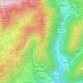
Name: Sormano topographic map, elevation, terrain.

Location: Sormano, Como, Lombardy, 22030, Italy (45.87165 9.20541 45.91399 9.25722)

Average elevation: 3,094 ft

Minimum elevation: 1,608 ft

Maximum elevation: 5,256 ft

Other topographic maps

Click on a map to view its topography, its elevation and its terrain.

Carcente

Italy > Lombardy > Como > San Siro > Acquaseria

Average elevation: 2,274 ft

Auvrascio

Italy > Lombardy > Como > Schignano > Occagno

Average elevation: 2,523 ft

Lenno

Italy > Lombardy > Como > Tremezzina

Average elevation: 1,253 ft

Lanzo d'Intelvi

Italy > Lombardy > Como

Average elevation: 2,831 ft

Rovenna

Italy > Lombardy > Como

Average elevation: 1,473 ft

San Fedele Intelvi

Italy > Lombardy > Como

Average elevation: 2,717 ft

Dicinisio

Italy > Lombardy > Como

Average elevation: 2,726 ft

Naggio

Italy > Lombardy > Como > Grandola ed Uniti

Average elevation: 2,136 ft

San Giorgio

Italy > Lombardy > Como > Solbiate con Cagno > Concagno

Average elevation: 1,312 ft

Casasco d'Intelvi

Italy > Lombardy > Como

Average elevation: 2,799 ft

Parè

Italy > Lombardy > Como > Colverde

Average elevation: 1,266 ft

Gear up for your next adventure:

🎒Trail Energy Bars - High‑calorie bars for hiking energy
🧥Waterproof Jacket for Hiking - Breathable and rugged rain jacket for outdoor excursions
🧭Orienteering Set - Complete compass and map reading kit
❄️Traction Cleats - Prevent slips on icy trails during winter hikes
🥤Water Filter Bottle - All‑in‑one filter bottle for safe hydration

As an Amazon Associate, this site earns from qualifying purchases at no extra cost to you.