
Make a donation
Gear up for your next adventure:
As an Amazon Associate, this site earns from qualifying purchases at no extra cost to you.
Lanzo d'Intelvi topographic map
Click on the map to display elevation.
Make a donation
Gear up for your next adventure:
As an Amazon Associate, this site earns from qualifying purchases at no extra cost to you.
About this map
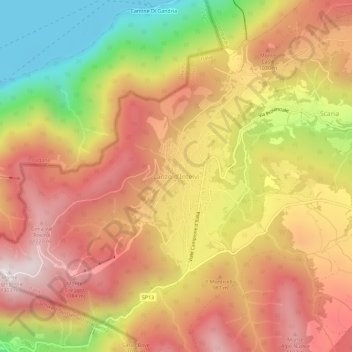
Name: Lanzo d'Intelvi topographic map, elevation, terrain.
Average elevation: 2,831 ft
Minimum elevation: 883 ft
Maximum elevation: 4,259 ft
Make a donation
Gear up for your next adventure:
As an Amazon Associate, this site earns from qualifying purchases at no extra cost to you.
Other topographic maps
Click on a map to view its topography, its elevation and its terrain.
Lake Como
Lake Como weather is humid subtropical (Cfa in the Köppen climate classification). In winter, the lake helps to maintain a higher temperature in the surrounding region. Average daily temperatures range from ~3.7 °C (39 °F) in January to 23.4 °C (74 °F) in July, according to historical weather data from…
Average elevation: 2,904 ft
Make a donation
Gear up for your next adventure:
As an Amazon Associate, this site earns from qualifying purchases at no extra cost to you.