
Apizaco topographic map
Click on the map to display elevation.
About this map
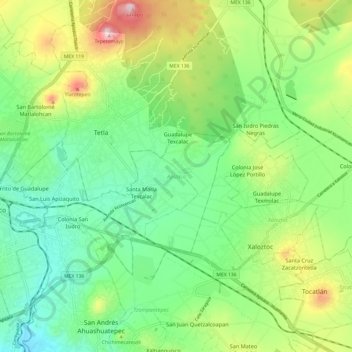
Name: Apizaco topographic map, elevation, terrain.
Location: Apizaco, Tlaxcala, Mexico (19.37261 -98.17981 19.48021 -98.05900)
Average elevation: 8,150 ft
Minimum elevation: 7,697 ft
Maximum elevation: 9,055 ft
Other topographic maps
Click on a map to view its topography, its elevation and its terrain.
Tlaxcala City
Mexico > Tlaxcala > Municipio de Tlaxcala
The city is located in the central Mexican highlands 2,239 metres (7,346 feet) above sea level, in a valley of the same name, from which the Popocatépetl and Iztaccíhuatl volcanoes can be seen in the distance. The main elevations in the municipality are El Cerro Ostol at 2,460 metres (8,070 feet) and El…
Average elevation: 7,920 ft
Huamantla
The municipality is located in the eastern half of the state of Tlaxcala, in the Central Mexican Highlands. It has an average altitude of 2,500 meters above sea level. The geography of the municipality has three types of relief. About twenty percent is rugged mountain (located in the far north and far south),…
Average elevation: 8,264 ft
Villa de El Carmen Tequexquitla
Mexico > Tlaxcala > El Carmen Tequexquitla
Average elevation: 7,808 ft