
Make a donation
Gear up for your next adventure:
As an Amazon Associate, this site earns from qualifying purchases at no extra cost to you.
Engenheiro Coelho topographic map
Click on the map to display elevation.
Make a donation
Gear up for your next adventure:
As an Amazon Associate, this site earns from qualifying purchases at no extra cost to you.
Engenheiro Coelho
Localiza-se a uma latitude 22º29'18" sul e a uma longitude 47º12'54" oeste, estando a uma altitude de 655 metros. Possui uma área de 109,8 km².
Make a donation
Gear up for your next adventure:
As an Amazon Associate, this site earns from qualifying purchases at no extra cost to you.
About this map
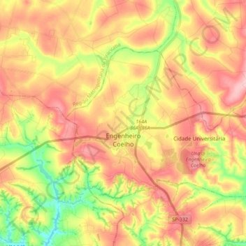
Name: Engenheiro Coelho topographic map, elevation, terrain.
Average elevation: 2,083 ft
Minimum elevation: 1,795 ft
Maximum elevation: 2,320 ft
Make a donation
Gear up for your next adventure:
As an Amazon Associate, this site earns from qualifying purchases at no extra cost to you.
Other topographic maps
Click on a map to view its topography, its elevation and its terrain.
Santa Bárbara d'Oeste
Brasil > São Paulo > Região Metropolitana de Campinas > Santa Bárbara d'Oeste
Average elevation: 1,903 ft
Lagoa dos Passáros
Brasil > São Paulo > Região Metropolitana de Campinas > Artur Nogueira
Average elevation: 2,087 ft
Recreio dos Cafezais
Brasil > São Paulo > Região Metropolitana de Campinas > Valinhos
Average elevation: 2,395 ft
Make a donation
Gear up for your next adventure:
As an Amazon Associate, this site earns from qualifying purchases at no extra cost to you.
Zona Leste (SBO)
Brasil > São Paulo > Região Metropolitana de Campinas > Santa Bárbara d'Oeste
Average elevation: 1,936 ft
Praça Arautos da Paz
Brasil > São Paulo > Região Metropolitana de Campinas > Campinas
Average elevation: 2,162 ft
Pedreira do Chapadão
Brasil > São Paulo > Região Metropolitana de Campinas > Campinas
Average elevation: 2,244 ft
Córrego da Lagoa
Brasil > São Paulo > Região Metropolitana de Campinas > Campinas
Average elevation: 1,978 ft
Make a donation
Gear up for your next adventure:
As an Amazon Associate, this site earns from qualifying purchases at no extra cost to you.
Praça Jd Moacir Arruda
Brasil > São Paulo > Região Metropolitana de Campinas > Indaiatuba
Average elevation: 2,021 ft
31 de Março
Brasil > São Paulo > Região Metropolitana de Campinas > Santa Bárbara d'Oeste
Average elevation: 1,831 ft
João Aranha
Brasil > São Paulo > Região Metropolitana de Campinas > Paulínia
Average elevation: 1,913 ft
Parque dos Lagos
Brasil > São Paulo > Região Metropolitana de Campinas > Valinhos
Average elevation: 2,343 ft
Make a donation
Gear up for your next adventure:
As an Amazon Associate, this site earns from qualifying purchases at no extra cost to you.
Vale das Cigarras
Brasil > São Paulo > Região Metropolitana de Campinas > Santa Bárbara d'Oeste
Average elevation: 1,762 ft
Rio Camanducaia
Brasil > São Paulo > Região Metropolitana de Campinas > Jaguariúna
Average elevation: 1,864 ft
MAAS(Museu Aberto de Astronomia)
Brasil > São Paulo > Região Metropolitana de Campinas > Campinas
Average elevation: 3,081 ft
Ribeirão Jacuba
Brasil > São Paulo > Região Metropolitana de Campinas > Hortolândia
Average elevation: 1,991 ft
Make a donation
Gear up for your next adventure:
As an Amazon Associate, this site earns from qualifying purchases at no extra cost to you.
Esmeralda Ville
Brasil > São Paulo > Região Metropolitana de Campinas > Campinas
Average elevation: 2,316 ft
Artur Nogueira
Brasil > São Paulo > Região Metropolitana de Campinas > Artur Nogueira > Artur Nogueira
Average elevation: 2,047 ft
Campo Grande
Brasil > São Paulo > Região Metropolitana de Campinas > Campinas
Average elevation: 1,972 ft
Indaiatuba
Brasil > São Paulo > Região Metropolitana de Campinas > Indaiatuba
Average elevation: 2,037 ft
Make a donation
Gear up for your next adventure:
As an Amazon Associate, this site earns from qualifying purchases at no extra cost to you.
Americana
Brasil > São Paulo > Região Metropolitana de Campinas > Americana
Average elevation: 1,903 ft
Praça Vitto Franciscatto
Brasil > São Paulo > Região Metropolitana de Campinas > Sumaré
Average elevation: 2,041 ft
Pico das Cabras
Brasil > São Paulo > Região Metropolitana de Campinas > Morungaba
Average elevation: 3,097 ft
Barão Geraldo
Brasil > São Paulo > Região Metropolitana de Campinas > Campinas
Average elevation: 2,005 ft
Make a donation
Gear up for your next adventure:
As an Amazon Associate, this site earns from qualifying purchases at no extra cost to you.
Ribeirão Anhumas
Brasil > São Paulo > Região Metropolitana de Campinas > Paulínia
Average elevation: 1,919 ft
Área de Relevante Interesse Ecológico Mata de Santa Genebra
Brasil > São Paulo > Região Metropolitana de Campinas > Paulínia
Average elevation: 1,998 ft
Parque e Barragem do Mirim
Brasil > São Paulo > Região Metropolitana de Campinas > Indaiatuba
Average elevation: 1,942 ft
Lagoa Isaura Teles Alves de Lima
Brasil > São Paulo > Região Metropolitana de Campinas > Campinas
Average elevation: 2,178 ft
Make a donation
Gear up for your next adventure:
As an Amazon Associate, this site earns from qualifying purchases at no extra cost to you.
Parque das Águas
Brasil > São Paulo > Região Metropolitana de Campinas > Campinas
Average elevation: 2,316 ft
Praça Euclides da Cunha
Brasil > São Paulo > Região Metropolitana de Campinas > Campinas
Average elevation: 2,247 ft
Buraco do Padre
Brasil > São Paulo > Região Metropolitana de Campinas > Santa Bárbara d'Oeste
Average elevation: 1,890 ft