
Erbaa topographic map
Interactive map
Click on the map to display elevation.
About this map
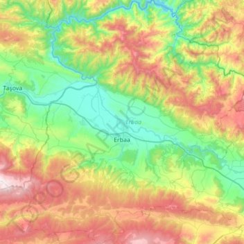
Name: Erbaa topographic map, elevation, terrain.
Location: Erbaa, Tokat, Black Sea Region, Turkey (40.49350 36.34539 40.91031 36.87274)
Average elevation: 2,507 ft
Minimum elevation: 505 ft
Maximum elevation: 6,414 ft
Other topographic maps
Click on a map to view its topography, its elevation and its terrain.
Reşadiye Belediyesi
Reşadiye Belediyesi, Reşadiye, Tokat, Black Sea Region, Turkey
Average elevation: 2,457 ft
Ekincik
Turkey > Tokat > Tokat Merkez
Ekincik, Tokat Merkez, Tokat, Black Sea Region, Turkey
Average elevation: 3,294 ft