Geolocate

Kinton topographic map

Click on the map to display elevation.

About this map

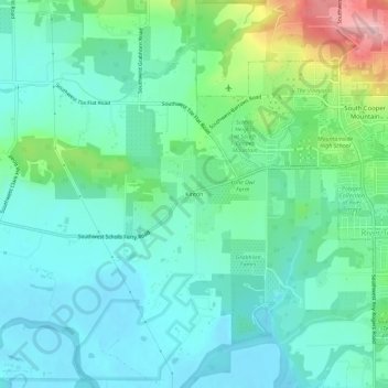
Name: Kinton topographic map, elevation, terrain.

Location: Kinton, Washington County, Oregon, 97007, United States (45.40309 -122.89811 45.44309 -122.85811)

Average elevation: 256 ft

Minimum elevation: 112 ft

Maximum elevation: 725 ft

Washington County trails, hiking, mountain biking, running and outdoor activities

Other topographic maps

Click on a map to view its topography, its elevation and its terrain.

North Plains

United States > Oregon > Washington County

Average elevation: 187 ft

Rock Creek

United States > Oregon > Washington County

Average elevation: 213 ft

Aloha

United States > Oregon > Washington County

Average elevation: 217 ft

King City

United States > Oregon > Washington County

Average elevation: 243 ft

Vose

United States > Oregon > Washington County > Beaverton

Average elevation: 230 ft

Gear up for your next adventure:

🧭Compass with Lanyard - Easy‑carry compass for navigation
🛶Inflatable Kayak - Portable kayak for rivers, lakes, and expeditions
🦺Reflective Outdoor Gear - Safety gear for low‑light conditions
Camping Coffee Makers - Enjoy premium coffee at the summit or campsite
🗃️Trail First Aid Kit - Essential kit for outdoor injuries and emergencies

As an Amazon Associate, this site earns from qualifying purchases at no extra cost to you.