
Fullerton topographic map
Click on the map to display elevation.
Fullerton
Fullerton is located at 33°52′48″N 117°55′43″W / 33.88000°N 117.92861°W / 33.88000; -117.92861 (33.879914, -117.928749). It is approximately 25 miles (40 km) southeast of downtown Los Angeles, and approximately 11 miles (18 km) north-northwest of Santa Ana, the county seat. The city has a mean elevation of 150 feet (46 m) and lies approximately 11 miles (18 km) northeast of the Pacific Ocean straight-line distance. It has a Mediterranean climate, with a mean temperature of 62.2 °F (16.8 °C).
About this map
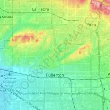
Name: Fullerton topographic map, elevation, terrain.
Location: Fullerton, Orange County, California, United States (33.85416 -117.98542 33.92446 -117.86371)
Average elevation: 259 ft
Minimum elevation: 82 ft
Maximum elevation: 738 ft
Orange County trails, hiking, mountain biking, running and outdoor activities
Other topographic maps
Click on a map to view its topography, its elevation and its terrain.
San Joaquin Hills
United States > California > Orange County > Newport Beach
Average elevation: 502 ft
Boulevard Gardens
United States > California > Orange County > Huntington Beach
Average elevation: 33 ft
Newport Beach
United States > California > Orange County > Newport Beach > Newport Beach
Newport Beach extends in elevation from sea level to the 1,161 ft (354 m) summit of Signal Peak in the San Joaquin Hills, but the official elevation is 25 ft (7.6 m) above sea level at a location of 33°37′0″N 117°53′51″W / 33.61667°N 117.89750°W / 33.61667; -117.89750 (33.616671, −117.897604).
Average elevation: 30 ft
San Joaquin Hills
United States > California > Orange County > Newport Beach
Average elevation: 502 ft
San Joaquin Hills
United States > California > Orange County > Newport Beach
Average elevation: 502 ft
San Joaquin Hills
United States > California > Orange County > Newport Beach
Average elevation: 502 ft
San Joaquin Hills
United States > California > Orange County > Newport Beach
Average elevation: 502 ft
Huntington Beach
United States > California > Orange County > Huntington Beach
Average elevation: 52 ft