
Make a donation
Gear up for your next adventure:
As an Amazon Associate, this site earns from qualifying purchases at no extra cost to you.
Ashebrook Park topographic map
Click on the map to display elevation.
Make a donation
Gear up for your next adventure:
As an Amazon Associate, this site earns from qualifying purchases at no extra cost to you.
About this map
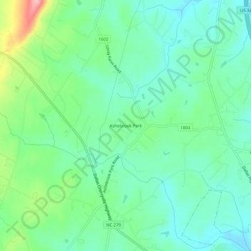
Name: Ashebrook Park topographic map, elevation, terrain.
Average elevation: 843 ft
Minimum elevation: 722 ft
Maximum elevation: 1,161 ft
Gaston County trails, hiking, mountain biking, running and outdoor activities
Make a donation
Gear up for your next adventure:
As an Amazon Associate, this site earns from qualifying purchases at no extra cost to you.
Other topographic maps
Click on a map to view its topography, its elevation and its terrain.
Make a donation
Gear up for your next adventure:
As an Amazon Associate, this site earns from qualifying purchases at no extra cost to you.
Cramerton
United States > North Carolina > Gaston County
Cramerton is located at an elevation of 620 feet (189 m). Two topographic high points, Berry Mountain, elevation 922 feet (281 m), and Cramer Mountain, approximate elevation 850 feet (259 m), are located in the southwestern part of town.
Average elevation: 663 ft
Make a donation
Gear up for your next adventure:
As an Amazon Associate, this site earns from qualifying purchases at no extra cost to you.