
East Riding of Yorkshire topographic map
Interactive map
Click on the map to display elevation.
About this map
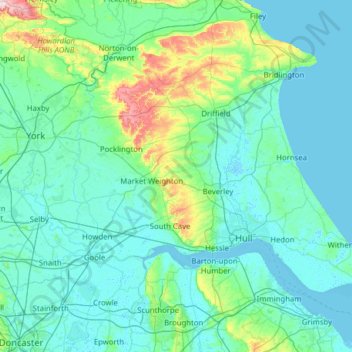
Name: East Riding of Yorkshire topographic map, elevation, terrain.
Location: East Riding of Yorkshire, England, United Kingdom (53.57059 -1.10357 54.17652 0.14983)
Average elevation: 98 ft
Minimum elevation: -7 ft
Maximum elevation: 991 ft
The western part of the district in the Vale of York borders on and is drained by the River Derwent. The landscape is generally low-lying and flat although minor ridges and glacial moraines provide some variations in topography. Where there are dry sandy soils there are remnants of historic heathlands and ancient semi-natural woodlands. Arable fields dominate the land cover of the area and grasslands are infrequent. There are very few flood meadows left, although some significant areas remain on the lower reaches of the River Derwent.
Other topographic maps
Click on a map to view its topography, its elevation and its terrain.
Stonehenge
United Kingdom > England > Larkhill
Stonehenge, The Avenue, Amesbury, Larkhill, Wiltshire, South West England, England, SP3 4DX, United Kingdom
Average elevation: 325 ft
Water
United Kingdom > England > Devon > Teignbridge
Water, Teignbridge, Devon, England, TQ13 9UE, United Kingdom
Average elevation: 856 ft
City of London
United Kingdom > England > City of London > City of London
City of London, England, EC2V 5AE, United Kingdom
Average elevation: 138 ft
Shrewsbury
United Kingdom > England > Shrewsbury
Shrewsbury, Shropshire, West Midlands, England, SY1 1SF, United Kingdom
Average elevation: 233 ft
Warmley
United Kingdom > England > South Gloucestershire
Warmley, Siston, South Gloucestershire, West of England, England, BS15 4PP, United Kingdom
Average elevation: 226 ft
Walney Channel
United Kingdom > England > Westmorland and Furness > Roa Island
Walney Channel, Roa Island, Westmorland and Furness, England, United Kingdom
Average elevation: 13 ft
Rotherham
Rotherham, South Yorkshire Mayoral Combined Authority, England, United Kingdom
Average elevation: 331 ft
Batley
United Kingdom > England > Kirklees
Batley, Kirklees, West Yorkshire, England, WF17 8PA, United Kingdom
Average elevation: 364 ft
London
London, Greater London, England, United Kingdom
Average elevation: 217 ft
Blackwater
United Kingdom > England > Cornwall
Blackwater, Cornwall, England, TR4 8EH, United Kingdom
Average elevation: 374 ft
Great Baddow
United Kingdom > England > Essex > Chelmsford
Great Baddow, Chelmsford, Essex, England, United Kingdom
Average elevation: 121 ft
Northampton
United Kingdom > England > West Northamptonshire > Northampton
Northampton, West Northamptonshire, England, United Kingdom
Average elevation: 292 ft
Whitnash
United Kingdom > England > Warwickshire > Warwick
Whitnash, Warwick, Warwickshire, England, United Kingdom
Average elevation: 226 ft
One Tree Close
United Kingdom > England > London
One Tree Close, Nunhead, London Borough of Southwark, London, Greater London, England, SE23 3QZ, United Kingdom
Average elevation: 141 ft
Sunderland
Sunderland, North East, England, United Kingdom
Average elevation: 151 ft
North West Leicestershire
United Kingdom > England > Leicestershire
North West Leicestershire, Leicestershire, England, United Kingdom
Average elevation: 331 ft
Hadleigh
United Kingdom > England > Essex > Castle Point
Hadleigh, Castle Point, Essex, England, SS7 2RD, United Kingdom
Average elevation: 95 ft
Royal Leamington Spa
United Kingdom > England > Royal Leamington Spa
Royal Leamington Spa, Warwickshire, West Midlands, England, CV32 4DB, United Kingdom
Average elevation: 223 ft
Great Staughton
United Kingdom > England > Cambridgeshire > Huntingdonshire
Great Staughton, Huntingdonshire, Cambridgeshire, Cambridgeshire and Peterborough, England, United Kingdom
Average elevation: 141 ft
County Durham
County Durham, North East, England, United Kingdom
Average elevation: 640 ft
Adstone
United Kingdom > England > West Northamptonshire
Adstone, West Northamptonshire, England, United Kingdom
Average elevation: 495 ft
Nether Heyford
United Kingdom > England > West Northamptonshire
Nether Heyford, West Northamptonshire, England, United Kingdom
Average elevation: 299 ft
Hadleigh
United Kingdom > England > Suffolk > Babergh
Hadleigh, Babergh, Suffolk, England, United Kingdom
Average elevation: 167 ft
Coventry
Coventry, West Midlands Combined Authority, England, United Kingdom
Average elevation: 325 ft
Rayleigh
United Kingdom > England > Essex
Rayleigh, Rochford, Essex, England, United Kingdom
Average elevation: 121 ft
Broxtowe
United Kingdom > England > Nottinghamshire
Broxtowe, Nottinghamshire, England, United Kingdom
Average elevation: 249 ft
Whitby
United Kingdom > England > Whitby
Whitby, North Yorkshire, Yorkshire and the Humber, England, YO21 3QF, United Kingdom
Average elevation: 128 ft
Coseley
Coseley, Dudley, West Midlands Combined Authority, England, WV14 9NJ, United Kingdom
Average elevation: 509 ft
Landican
United Kingdom > England > Thingwall
Landican, Thingwall, Wirral, Liverpool City Region, England, CH49 5LJ, United Kingdom
Average elevation: 148 ft
Elsdon
United Kingdom > England > Northumberland
Elsdon, Northumberland, North of Tyne, England, United Kingdom
Average elevation: 807 ft
Hanham
United Kingdom > England > South Gloucestershire
Hanham, South Gloucestershire, West of England, England, United Kingdom
Average elevation: 233 ft
Tetbury
United Kingdom > England > Gloucestershire > Cotswold District
Tetbury, Cotswold District, Gloucestershire, England, United Kingdom
Average elevation: 400 ft
Old Brampton
United Kingdom > England > Derbyshire > North East Derbyshire
Old Brampton, North East Derbyshire, Derbyshire, England, S42 7JG, United Kingdom
Average elevation: 594 ft
Broadstairs
United Kingdom > England > Kent > Thanet
Broadstairs, Thanet, Kent, England, CT10 1LH, United Kingdom
Average elevation: 46 ft
Woolavington
United Kingdom > England > Somerset
Woolavington, Somerset, England, United Kingdom
Average elevation: 56 ft
Cruwys Morchard
United Kingdom > England > Devon > Mid Devon
Cruwys Morchard, Mid Devon, Devon, England, United Kingdom
Average elevation: 636 ft
Codsall
United Kingdom > England > Staffordshire > South Staffordshire
Codsall, South Staffordshire, Staffordshire, England, United Kingdom
Average elevation: 407 ft
Allesley
United Kingdom > England > Coventry
Allesley, Coventry, West Midlands Combined Authority, England, CV5 9GS, United Kingdom
Average elevation: 377 ft
Offham
United Kingdom > England > Kent > Tonbridge and Malling
Offham, Tonbridge and Malling, Kent, England, United Kingdom
Average elevation: 315 ft
Carlisle
United Kingdom > England > Cumberland
Carlisle, Cumberland, England, United Kingdom
Average elevation: 102 ft
Alveley
United Kingdom > England > Shropshire
Alveley, Shropshire, England, WV15 6PQ, United Kingdom
Average elevation: 335 ft
Goring-on-Thames
United Kingdom > England > Oxfordshire > South Oxfordshire
Goring-on-Thames, South Oxfordshire, Oxfordshire, England, RG8 0EB, United Kingdom
Average elevation: 276 ft
Kingsley Holt
United Kingdom > England > Staffordshire > Staffordshire Moorlands
Kingsley Holt, Staffordshire Moorlands, Staffordshire, England, ST10 2BG, United Kingdom
Average elevation: 604 ft
White Cliffs of Dover
United Kingdom > England > Kent > Dover > St. Margaret's at Cliffe
White Cliffs of Dover, St. Margaret's at Cliffe, Dover, Kent, England, United Kingdom
Average elevation: 161 ft
Welford
United Kingdom > England > West Berkshire
Welford, West Berkshire, England, United Kingdom
Average elevation: 407 ft
Goblin Ledge
United Kingdom > England > South Gloucestershire > Severn Beach > New Passage
Goblin Ledge, Prince of Wales Bridge, New Passage, Pilning and Severn Beach, Severn Beach, South Gloucestershire, West of England, England, BS35 4NQ, United Kingdom
Average elevation: 7 ft
Fenny Bentley CP
United Kingdom > England > Derbyshire > Derbyshire Dales
Fenny Bentley CP, Derbyshire Dales, Derbyshire, England, United Kingdom
Average elevation: 633 ft
Olveston
United Kingdom > England > South Gloucestershire
Olveston, South Gloucestershire, West of England, England, United Kingdom
Average elevation: 102 ft
Dalbury
United Kingdom > England > Derbyshire > South Derbyshire
Dalbury, Dalbury Lees CP, South Derbyshire, Derbyshire, England, DE6 5BR, United Kingdom
Average elevation: 249 ft