Geolocate

Alveley topographic map

Click on the map to display elevation.

About this map

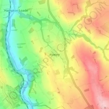
Name: Alveley topographic map, elevation, terrain.

Location: Alveley, Shropshire, England, WV15 6PQ, United Kingdom (52.43846 -2.36999 52.47846 -2.32999)

Average elevation: 335 ft

Minimum elevation: 75 ft

Maximum elevation: 627 ft

Other topographic maps

Click on a map to view its topography, its elevation and its terrain.

Aston Botterell

United Kingdom > England > Shropshire

Average elevation: 666 ft

Church Stretton

United Kingdom > England > Shropshire

Average elevation: 919 ft

Broseley

United Kingdom > England > Shropshire

Average elevation: 466 ft

Much Wenlock

United Kingdom > England > Shropshire

Average elevation: 522 ft

Romsley

United Kingdom > England > Shropshire

Average elevation: 440 ft

Cedars of Lebanon

United Kingdom > England > Shropshire > Atcham

Average elevation: 171 ft

Gear up for your next adventure:

🥇GPS Hiking Watch - Multi‑sport GPS watch with navigation and trail tracking
🪓Survival Multi‑Tool - Versatile tool for camp and trail tasks
🗃️Trail First Aid Kit - Essential kit for outdoor injuries and emergencies
🎒Waterproof Dry Bags - Keep your electronics and maps dry inside your pack
🧦Hiking Socks - Comfortable socks to prevent blisters on long hikes

As an Amazon Associate, this site earns from qualifying purchases at no extra cost to you.