
Make a donation
Gear up for your next adventure:
As an Amazon Associate, this site earns from qualifying purchases at no extra cost to you.
Chiniguchi River topographic map
Click on the map to display elevation.
Make a donation
Gear up for your next adventure:
As an Amazon Associate, this site earns from qualifying purchases at no extra cost to you.
About this map
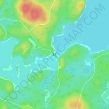
Name: Chiniguchi River topographic map, elevation, terrain.
Average elevation: 853 ft
Minimum elevation: 791 ft
Maximum elevation: 1,010 ft
Make a donation
Gear up for your next adventure:
As an Amazon Associate, this site earns from qualifying purchases at no extra cost to you.
Other topographic maps
Click on a map to view its topography, its elevation and its terrain.
Kipawa Lake
Canada > Ontario > Sudbury District > Unorganized North Sudbury
Average elevation: 1,512 ft
Portal Lake
Canada > Ontario > Sudbury District > Unorganized North Sudbury
Average elevation: 1,460 ft
Demott Lake
Canada > Ontario > Sudbury District > Unorganized North Sudbury
Average elevation: 1,293 ft
Make a donation
Gear up for your next adventure:
As an Amazon Associate, this site earns from qualifying purchases at no extra cost to you.
Whitefish Falls
Canada > Ontario > Sudbury District > Unorganized North Sudbury
Average elevation: 673 ft
Pineal Creek;Pineal Lake
Canada > Ontario > Sudbury District > Unorganized North Sudbury
Average elevation: 1,490 ft