
Dighton topographic map
Click on the map to display elevation.
Dighton
Dighton is bordered by Rehoboth to the west, Swansea to the southwest, Somerset to the south, the Taunton River and the town of Berkley to the east, and the city of Taunton to the north. In addition to being bordered by the Taunton River, it also is bordered by the Three Mile River, a tributary which empties into the Taunton along the northeast border of town. The town is also crossed by the Segreganset River, another tributary of the Taunton which flows through the center of town, as well as several smaller brooks. The highest point in the town is in its northwest corner, where the elevation rises above 236 feet (72 m) above sea level.
About this map
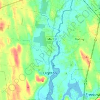
Name: Dighton topographic map, elevation, terrain.
Location: Dighton, Bristol County, Massachusetts, United States (41.78937 -71.20346 41.88184 -71.10749)
Average elevation: 59 ft
Minimum elevation: -13 ft
Maximum elevation: 187 ft
Bristol County trails, hiking, mountain biking, running and outdoor activities
Other topographic maps
Click on a map to view its topography, its elevation and its terrain.
Kirby Corner
United States > Massachusetts > Bristol County > Westport > Kirby Corner
Average elevation: 108 ft
North Attleborough
United States > Massachusetts > Bristol County > North Attleborough > North Attleborough
Average elevation: 213 ft
Fall River Station
United States > Massachusetts > Bristol County > Fall River > Fall River Station
Average elevation: 92 ft
Rehoboth
United States > Massachusetts > Bristol County > Rehoboth > Rehoboth
Average elevation: 85 ft
Attleborough City
United States > Massachusetts > Bristol County > Attleboro
Average elevation: 115 ft
Source Is Shapefile From Town
United States > Massachusetts > Bristol County > Mansfield > Robinsonville
Average elevation: 164 ft
Brownell Corner
United States > Massachusetts > Bristol County > Westport > Brownell Corner
Average elevation: 161 ft