
Make a donation
Gear up for your next adventure:
As an Amazon Associate, this site earns from qualifying purchases at no extra cost to you.
Flanagan Lake topographic map
Click on the map to display elevation.
Make a donation
Gear up for your next adventure:
As an Amazon Associate, this site earns from qualifying purchases at no extra cost to you.
About this map
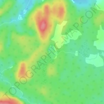
Name: Flanagan Lake topographic map, elevation, terrain.
Average elevation: 1,322 ft
Minimum elevation: 1,211 ft
Maximum elevation: 1,499 ft
Make a donation
Gear up for your next adventure:
As an Amazon Associate, this site earns from qualifying purchases at no extra cost to you.
Other topographic maps
Click on a map to view its topography, its elevation and its terrain.
Lady Evelyn Lake
Canada > Ontario > Timiskaming District > Unorganized West Timiskaming
Average elevation: 1,043 ft
Wabun Lake
Canada > Ontario > Timiskaming District > Unorganized West Timiskaming
Average elevation: 1,535 ft
Lake Temiskaming
Canada > Ontario > Timiskaming District > Unorganized West Timiskaming
Average elevation: 915 ft
Wolf Creek
Canada > Ontario > Timiskaming District > Unorganized West Timiskaming
Average elevation: 1,073 ft
Make a donation
Gear up for your next adventure:
As an Amazon Associate, this site earns from qualifying purchases at no extra cost to you.
Okiniada Lake
Canada > Ontario > Timiskaming District > Unorganized West Timiskaming
Average elevation: 1,535 ft
Kenabeek
Canada > Ontario > Timiskaming District > Unorganized West Timiskaming
Average elevation: 932 ft
Kenogami Lake
Canada > Ontario > Timiskaming District > Unorganized West Timiskaming
Average elevation: 1,037 ft
Wendigo Lake
Canada > Ontario > Timiskaming District > Unorganized West Timiskaming
Average elevation: 919 ft
Make a donation
Gear up for your next adventure:
As an Amazon Associate, this site earns from qualifying purchases at no extra cost to you.
Lady Evelyn Lake
Canada > Ontario > Timiskaming District > Unorganized West Timiskaming
Average elevation: 1,043 ft