
Lake Temiskaming topographic map
Click on the map to display elevation.
About this map
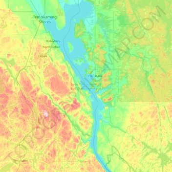
Name: Lake Temiskaming topographic map, elevation, terrain.
Average elevation: 915 ft
Minimum elevation: 564 ft
Maximum elevation: 1,690 ft
Other topographic maps
Click on a map to view its topography, its elevation and its terrain.
Kenabeek
Canada > Ontario > Timiskaming District > Unorganized West Timiskaming
Average elevation: 932 ft
Henwood Lake
Canada > Ontario > Timiskaming District > Unorganized West Timiskaming
Average elevation: 945 ft
Boston Creek
Canada > Ontario > Timiskaming District > Unorganized West Timiskaming
Average elevation: 984 ft
Baptiste Creek;Baptiste Lake
Canada > Ontario > Timiskaming District > Unorganized West Timiskaming
Average elevation: 1,096 ft
Flanagan Lake
Canada > Ontario > Timiskaming District > Unorganized West Timiskaming
Average elevation: 1,322 ft
Heart Lake
Canada > Ontario > Timiskaming District > Unorganized West Timiskaming > King Kirkland
Average elevation: 1,102 ft
Hobart Lake
Canada > Ontario > Timiskaming District > Unorganized West Timiskaming
Average elevation: 1,001 ft