
Sariñena topographic map
Interactive map
Click on the map to display elevation.
About this map
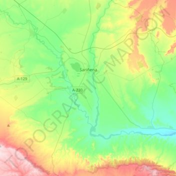
Name: Sariñena topographic map, elevation, terrain.
Location: Sariñena, Los Monegros, Huesca, Aragon, 22213, Spain (41.65056 -0.30811 41.88605 -0.03043)
Average elevation: 1,089 ft
Minimum elevation: 623 ft
Maximum elevation: 2,070 ft
Other topographic maps
Click on a map to view its topography, its elevation and its terrain.
Montemar
Spain > Aragon > Los Monegros > Farlete
Montemar, Farlete, Los Monegros, Zaragoza, Aragon, Spain
Average elevation: 2,146 ft
Ordesa
Spain > Aragon > Los Monegros > Almuniente
Ordesa, Almuniente, Los Monegros, Huesca, Aragon, Spain
Average elevation: 1,119 ft