
Lyons topographic map
Click on the map to display elevation.
About this map
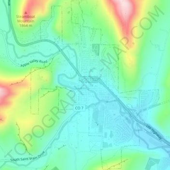
Name: Lyons topographic map, elevation, terrain.
Location: Lyons, Boulder County, Colorado, United States (40.20856 -105.28303 40.23814 -105.24403)
Average elevation: 5,545 ft
Minimum elevation: 5,276 ft
Maximum elevation: 6,276 ft
Boulder County trails, hiking, mountain biking, running and outdoor activities
Other topographic maps
Click on a map to view its topography, its elevation and its terrain.
Longs Peak
United States > Colorado > Boulder County
Together with nearby Mount Meeker, with an elevation of 13,911 feet, the two mountains are sometimes referred to as the Twin Peaks (not to be confused with a nearby lower mountain called Twin Sisters).
Average elevation: 12,549 ft
Boulder
United States > Colorado > Boulder County > Boulder
Boulder is located at the base of the foothills of the Rocky Mountains, at an elevation of 5,430 feet (1,655 m) above sea level. Boulder is 25 miles (40 km) northwest of the Colorado State Capitol in Denver. It is home of the main campus of the University of Colorado, the state's largest university.
Average elevation: 6,486 ft
Monument Hill
United States > Colorado > Boulder County
Monument Hill or Black Forest Divide Pass is a 7,352 feet (2,241 m) elevation mountain pass in the Palmer Divide in central Colorado in the United States. The pass dividing the Arkansas River drainage system to the south and the Platte River drainage system to the north is the high point on I-25 between Denver…
Average elevation: 7,595 ft
Nederland
United States > Colorado > Boulder County
In 1873 the Caribou Mine, at an elevation of roughly 10,000 feet (3,000 m) and 6 miles (10 km) northwest of the town, was sold to the Mining Company Nederland from the Netherlands. The high elevation meant fierce winds and deep winter snow, so the new owners of the mine decided that it was beneficial to bring…
Average elevation: 8,458 ft
National Center for Atmospheric Research
United States > Colorado > Boulder County > Boulder
Average elevation: 5,958 ft
Longs Peak
United States > Colorado > Boulder County
Together with nearby Mount Meeker, with an elevation of 13,911 feet, the two mountains are sometimes referred to as the Twin Peaks (not to be confused with a nearby lower mountain called Twin Sisters).
Average elevation: 12,549 ft
South Boulder Canyon Ditch
United States > Colorado > Boulder County > Lafayette
Average elevation: 5,308 ft
Sombrero Marsh
United States > Colorado > Boulder County > Boulder Junction
Average elevation: 5,266 ft