
Niwot Ridge topographic map
Click on the map to display elevation.
About this map
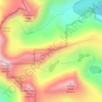
Name: Niwot Ridge topographic map, elevation, terrain.
Location: Niwot Ridge, Boulder County, Colorado, United States (40.05349 -105.64460 40.05975 -105.61707)
Average elevation: 12,047 ft
Minimum elevation: 10,719 ft
Maximum elevation: 13,271 ft
Boulder County trails, hiking, mountain biking, running and outdoor activities
Other topographic maps
Click on a map to view its topography, its elevation and its terrain.
Boulder
United States > Colorado > Boulder County
Boulder is located at the base of the foothills of the Rocky Mountains, at an elevation of 5,430 feet (1,655 m) above sea level. Boulder is 25 miles (40 km) northwest of the Colorado state capital of Denver. It is home of the main campus of the University of Colorado, the state's largest university.
Average elevation: 5,906 ft
Longmont
United States > Colorado > Boulder County
The elevation at City Hall is 4,978 feet (1,517 m) above sea level. St. Vrain Creek, a tributary of the South Platte River, flows through the city just south of the city center.
Average elevation: 5,043 ft
Longs Peak
United States > Colorado > Boulder County
Together with nearby Mount Meeker, with an elevation of 13,911 feet, the two mountains are sometimes referred to as the Twin Peaks (not to be confused with a nearby lower mountain called Twin Sisters).
Average elevation: 12,549 ft
Allenspark
United States > Colorado > Boulder County
Allenspark is located in northwest Boulder County within Roosevelt National Forest in the Front Range of the Colorado Rockies. The western edge of the community is the boundary of Rocky Mountain National Park. State Highway 7 passes through the community, leading north 15 miles (24 km) to Estes Park and east…
Average elevation: 9,429 ft
Nederland
United States > Colorado > Boulder County
In 1873 the Caribou Mine, at an elevation of roughly 10,000 feet (3,000 m) and 6 miles (10 km) northwest of the town, was sold to the Mining Company Nederland from the Netherlands. The high elevation meant fierce winds and deep winter snow, so the new owners of the mine decided that it was beneficial to bring…
Average elevation: 8,458 ft
Ward
United States > Colorado > Boulder County
Ward is a home rule municipality in Boulder County, Colorado, United States. The population was 128 at the 2020 census. The town is a former mining settlement founded in 1860 in the wake of the discovery of gold at nearby Gold Hill. Once one of the richest towns in the state during the Colorado Gold Rush, it…
Average elevation: 9,272 ft
Gunbarrel
United States > Colorado > Boulder County > Gunbarrel
Gunbarrel is northeast of the city of Boulder proper, separated by a buffer area of private agricultural lands and publicly owned open space. The buffer areas provide over two miles (3 km) of separation over changing elevations.
Average elevation: 5,200 ft
Ward
United States > Colorado > Boulder County
Ward is a home rule municipality in Boulder County, Colorado, United States. The population was 128 at the 2020 census. The town is a former mining settlement founded in 1860 in the wake of the discovery of gold at nearby Gold Hill. Once one of the richest towns in the state during the Colorado Gold Rush, it…
Average elevation: 9,262 ft
Boulder
United States > Colorado > Boulder County > Boulder
Boulder is located at the base of the foothills of the Rocky Mountains, at an elevation of 5,430 feet (1,655 m) above sea level. Boulder is 25 miles (40 km) northwest of the Colorado State Capitol in Denver. It is home of the main campus of the University of Colorado, the state's largest university.
Average elevation: 6,486 ft
Monument Hill
United States > Colorado > Boulder County
Monument Hill or Black Forest Divide Pass is a 7,352 feet (2,241 m) elevation mountain pass in the Palmer Divide in central Colorado in the United States. The pass dividing the Arkansas River drainage system to the south and the Platte River drainage system to the north is the high point on I-25 between Denver…
Average elevation: 7,595 ft
Boulder
United States > Colorado > Boulder County
Boulder is located at the base of the foothills of the Rocky Mountains, at an elevation of 5,430 feet (1,655 m) above sea level. The city is 25 miles (40 km) northwest of the Colorado state capital of Denver. Boulder is a college town, hosting the University of Colorado Boulder, the flagship and largest campus…
Average elevation: 5,906 ft
Nederland
United States > Colorado > Boulder County
In 1873 the Caribou Mine, at an elevation of roughly 10,000 feet (3,000 m) and 6 miles (10 km) northwest of the town, was sold to the Mining Company Nederland from the Netherlands. The high elevation meant fierce winds and deep winter snow, so the new owners of the mine decided that it was beneficial to bring…
Average elevation: 8,458 ft
Boulder
United States > Colorado > Boulder County
Boulder is located at the base of the foothills of the Rocky Mountains, at an elevation of 5,430 feet (1,655 m) above sea level. The city is 25 miles (40 km) northwest of the Colorado state capital of Denver. Boulder is a college town, hosting the University of Colorado Boulder, the flagship and largest campus…
Average elevation: 5,906 ft
Longs Peak
United States > Colorado > Boulder County
Together with nearby Mount Meeker, with an elevation of 13,911 feet, the two mountains are sometimes referred to as the Twin Peaks (not to be confused with a nearby lower mountain called Twin Sisters).
Average elevation: 12,549 ft
Longmont
United States > Colorado > Boulder County
The elevation at City Hall is 4,978 feet (1,517 m) above sea level. St. Vrain Creek, a tributary of the South Platte River, flows through the city just south of the city center.
Average elevation: 5,043 ft
Boulder
United States > Colorado > Boulder County
Boulder is located at the base of the foothills of the Rocky Mountains, at an elevation of 5,430 feet (1,655 m) above sea level. The city is 25 miles (40 km) northwest of the Colorado state capital of Denver. Boulder is a college town, hosting the largest campus of the University of Colorado (the state's…
Average elevation: 5,906 ft
Allenspark
United States > Colorado > Boulder County
Allenspark is located in northwest Boulder County within Roosevelt National Forest in the Front Range of the Colorado Rockies. The western edge of the community is the boundary of Rocky Mountain National Park. State Highway 7 passes through the community, leading north 15 miles (24 km) to Estes Park and east…
Average elevation: 9,429 ft
Ward
United States > Colorado > Boulder County
Ward is a home rule municipality in Boulder County, Colorado, United States. The population was 128 at the 2020 census. The town is a former mining settlement founded in 1860 in the wake of the discovery of gold at nearby Gold Hill. Once one of the richest towns in the state during the Colorado Gold Rush, it…
Average elevation: 9,272 ft
Longmont
United States > Colorado > Boulder County
The elevation at City Hall is 4,978 feet (1,517 m) above sea level. St. Vrain Creek, a tributary of the South Platte River, flows through the city just south of the city center.
Average elevation: 5,033 ft