
Make a donation
Gear up for your next adventure:
As an Amazon Associate, this site earns from qualifying purchases at no extra cost to you.
Dingman Township topographic map
Click on the map to display elevation.
Make a donation
Gear up for your next adventure:
As an Amazon Associate, this site earns from qualifying purchases at no extra cost to you.
About this map
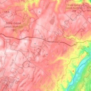
Name: Dingman Township topographic map, elevation, terrain.
Location: Dingman Township, Pike County, Pennsylvania, United States (41.27635 -75.04504 41.39041 -74.79183)
Average elevation: 1,194 ft
Minimum elevation: 341 ft
Maximum elevation: 1,604 ft
Pike County trails, hiking, mountain biking, running and outdoor activities
Make a donation
Gear up for your next adventure:
As an Amazon Associate, this site earns from qualifying purchases at no extra cost to you.
Other topographic maps
Click on a map to view its topography, its elevation and its terrain.
Dingmans Ferry
United States > Pennsylvania > Pike County > Delaware Township
Average elevation: 630 ft
Make a donation
Gear up for your next adventure:
As an Amazon Associate, this site earns from qualifying purchases at no extra cost to you.
Lake in the Clouds
United States > Pennsylvania > Pike County > Greene Township
Average elevation: 1,841 ft
Lords Valley
United States > Pennsylvania > Pike County > Blooming Grove Township
Average elevation: 1,352 ft
Make a donation
Gear up for your next adventure:
As an Amazon Associate, this site earns from qualifying purchases at no extra cost to you.
Parkers Glen
United States > Pennsylvania > Pike County > Shohola Township
Average elevation: 1,007 ft
Promised Land
United States > Pennsylvania > Pike County > Greene Township
Average elevation: 1,772 ft
Make a donation
Gear up for your next adventure:
As an Amazon Associate, this site earns from qualifying purchases at no extra cost to you.
Sagamore Estates
United States > Pennsylvania > Pike County > Shohola Township
Average elevation: 1,352 ft
Dingmans Ferry
United States > Pennsylvania > Pike County > Delaware Township
Average elevation: 630 ft
Tanglewood Estate
United States > Pennsylvania > Pike County > Palmyra Township
Average elevation: 1,470 ft
Make a donation
Gear up for your next adventure:
As an Amazon Associate, this site earns from qualifying purchases at no extra cost to you.
Masthope Rapids
United States > Pennsylvania > Pike County > Lackawaxen Township
Average elevation: 1,027 ft
Sagamore Estates
United States > Pennsylvania > Pike County > Shohola Township
Average elevation: 1,352 ft
Pocono Mountain Woodland Lakes
United States > Pennsylvania > Pike County > Dingman Township
Average elevation: 1,211 ft
Make a donation
Gear up for your next adventure:
As an Amazon Associate, this site earns from qualifying purchases at no extra cost to you.
Gold Key Lake
United States > Pennsylvania > Pike County > Dingman Township
Average elevation: 1,316 ft
Lords Valley
United States > Pennsylvania > Pike County > Blooming Grove Township
Average elevation: 1,352 ft
Make a donation
Gear up for your next adventure:
As an Amazon Associate, this site earns from qualifying purchases at no extra cost to you.
Promised Land
United States > Pennsylvania > Pike County > Greene Township
Average elevation: 1,772 ft
Saw Creek
United States > Pennsylvania > Pike County > Lehman Township > Saw Creek
Average elevation: 906 ft
Make a donation
Gear up for your next adventure:
As an Amazon Associate, this site earns from qualifying purchases at no extra cost to you.