
Wuhan topographic map
Click on the map to display elevation.
Wuhan
Other well-known lakes include South Lake and Sand Lake. Liangzi Lake, the largest lake by surface area in Hubei province, is located in the southeast of Jiangxia District.The twin peaks at the junction of Huangpi District and Xiaogan City, with an altitude of 872.5 meters, are the highest points in Wuhan. There are also several mountains within the city limits of Wuhan including Mount Luojia (珞珈山) in Wuchang District as well as Mount Hong (洪山) and Mount Yujia (喻家山/瑜珈山) in Hongshan District.
About this map
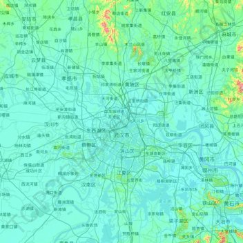
Name: Wuhan topographic map, elevation, terrain.
Location: Wuhan, Hubei, China (29.97196 113.69665 31.36224 115.07693)
Average elevation: 157 ft
Minimum elevation: 26 ft
Maximum elevation: 3,202 ft
Other topographic maps
Click on a map to view its topography, its elevation and its terrain.
Shiyan
The far northern and southern reaches of Shiyan are the highest in elevation, while the geographic center of the city has a relatively low elevation. The highest point in Shiyan is Congping in Zhuxi County, at 2,740.2 metres (8,990 ft) above sea level, while the lowest point, Panjiayan in Danjiangkou, is 87…
Average elevation: 1,385 ft
Mount Wudang
China > Hubei > Danjiangkou City
Modern maps show the elevation of the highest of the peaks in the Wudang Shan "proper" as 1612 meters; however, the entire Wudangshan range has somewhat higher elevations elsewhere.
Average elevation: 3,845 ft
Mount Wudang
China > Hubei > Danjiangkou City
Modern maps show the elevation of the highest of the peaks in the Wudang Shan "proper" as 1612 meters; however, the entire Wudangshan range has somewhat higher elevations elsewhere.
Average elevation: 3,845 ft
Mount Wudang
China > Hubei > Danjiangkou City
Modern maps show the elevation of the highest of the peaks in the Wudang Shan "proper" as 1612 meters; however, the entire Wudangshan range has somewhat higher elevations elsewhere.
Average elevation: 3,845 ft
Yuxi
Tempered by the low latitude and moderate elevation, Yuxi has a mild subtropical highland climate (Köppen Cwb), with short, mild, dry winters, and warm, rainy summers. Frost may occur in winter but the days still generally warm up to around 17 °C (63 °F). During summer, a majority of the days features some…
Average elevation: 217 ft