Geolocate

St. John topographic map

Click on the map to display elevation.

About this map

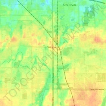
Name: St. John topographic map, elevation, terrain.

Location: St. John, Lake County, Indiana, 46373, United States (41.42004 -87.52589 41.47167 -87.42889)

Average elevation: 699 ft

Minimum elevation: 633 ft

Maximum elevation: 748 ft

Lake County trails, hiking, mountain biking, running and outdoor activities

Other topographic maps

Click on a map to view its topography, its elevation and its terrain.

Grand Calumet River

United States > Indiana > Lake County > Gary

Average elevation: 591 ft

Miller

United States > Indiana > Lake County > Gary

Average elevation: 610 ft

Osborn

United States > Indiana > Lake County > Hammond

Average elevation: 600 ft

Illinoi

United States > Indiana > Lake County

Average elevation: 630 ft

Gary

United States > Indiana > Lake County > Gary

Average elevation: 614 ft

Hammond

United States > Indiana > Lake County > Hammond > Hammond

Average elevation: 604 ft

Gear up for your next adventure:

🥇GPS Hiking Watch - Multi‑sport GPS watch with navigation and trail tracking
🍳Camping Cook Set - Complete cookware for outdoor meals
🥾Women's Hiking Boots - Top-rated trail boots with ankle support and superior grip
🔥Plasma Lighters - Windproof lighters that work in any weather condition
🛶Inflatable Kayak - Portable kayak for rivers, lakes, and expeditions

As an Amazon Associate, this site earns from qualifying purchases at no extra cost to you.