
Make a donation
Gear up for your next adventure:
As an Amazon Associate, this site earns from qualifying purchases at no extra cost to you.
Westport topographic map
Click on the map to display elevation.
Make a donation
Gear up for your next adventure:
As an Amazon Associate, this site earns from qualifying purchases at no extra cost to you.
About this map
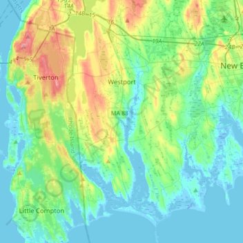
Name: Westport topographic map, elevation, terrain.
Location: Westport, Bristol County, Massachusetts, United States (41.48186 -71.13835 41.69280 -71.02231)
Average elevation: 75 ft
Minimum elevation: -72 ft
Maximum elevation: 302 ft
Bristol County trails, hiking, mountain biking, running and outdoor activities
Make a donation
Gear up for your next adventure:
As an Amazon Associate, this site earns from qualifying purchases at no extra cost to you.
Other topographic maps
Click on a map to view its topography, its elevation and its terrain.
Make a donation
Gear up for your next adventure:
As an Amazon Associate, this site earns from qualifying purchases at no extra cost to you.
Make a donation
Gear up for your next adventure:
As an Amazon Associate, this site earns from qualifying purchases at no extra cost to you.
North Attleborough
United States > Massachusetts > Bristol County > North Attleborough > North Attleborough
Average elevation: 213 ft
Make a donation
Gear up for your next adventure:
As an Amazon Associate, this site earns from qualifying purchases at no extra cost to you.
Make a donation
Gear up for your next adventure:
As an Amazon Associate, this site earns from qualifying purchases at no extra cost to you.
Attleborough City
United States > Massachusetts > Bristol County > Attleboro
Average elevation: 115 ft
Source Is Shapefile From Town
United States > Massachusetts > Bristol County > Mansfield > Robinsonville
Average elevation: 164 ft
Make a donation
Gear up for your next adventure:
As an Amazon Associate, this site earns from qualifying purchases at no extra cost to you.
Make a donation
Gear up for your next adventure:
As an Amazon Associate, this site earns from qualifying purchases at no extra cost to you.
Kirby Corner
United States > Massachusetts > Bristol County > Westport > Kirby Corner
Average elevation: 108 ft
Fall River Station
United States > Massachusetts > Bristol County > Fall River > Fall River Station
Average elevation: 92 ft
Make a donation
Gear up for your next adventure:
As an Amazon Associate, this site earns from qualifying purchases at no extra cost to you.
Rehoboth
United States > Massachusetts > Bristol County > Rehoboth > Rehoboth
Average elevation: 85 ft
Brownell Corner
United States > Massachusetts > Bristol County > Westport > Brownell Corner
Average elevation: 161 ft
Make a donation
Gear up for your next adventure:
As an Amazon Associate, this site earns from qualifying purchases at no extra cost to you.