Geolocate

Four Elms topographic map

Click on the map to display elevation.

About this map

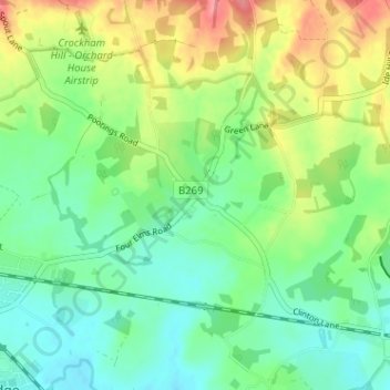
Name: Four Elms topographic map, elevation, terrain.

Location: Four Elms, Hever, Sevenoaks, Kent, England, TN8 6NL, United Kingdom (51.19575 0.07873 51.23575 0.11873)

Average elevation: 220 ft

Minimum elevation: 121 ft

Maximum elevation: 404 ft

Other topographic maps

Click on a map to view its topography, its elevation and its terrain.

Eynsford

United Kingdom > England > Kent > Sevenoaks > Eynsford

Average elevation: 341 ft

Kemsing

United Kingdom > England > Kent > Sevenoaks

Average elevation: 456 ft

Darent

United Kingdom > England > Kent > Sevenoaks

Average elevation: 302 ft

Sevenoaks

United Kingdom > England > Kent > Sevenoaks

Average elevation: 417 ft

Chiddingstone

United Kingdom > England > Kent > Sevenoaks

Average elevation: 210 ft

Riverhead

United Kingdom > England > Kent > Sevenoaks

Average elevation: 430 ft

Shoreham

United Kingdom > England > Kent > Sevenoaks

Average elevation: 404 ft

Bough Beech Reservoir

United Kingdom > England > Kent > Sevenoaks

Average elevation: 256 ft

Hartley

United Kingdom > England > Kent > Sevenoaks

Average elevation: 325 ft

Fawkham

United Kingdom > England > Kent > Sevenoaks

Average elevation: 354 ft

Cowden

United Kingdom > England > Kent > Sevenoaks

Average elevation: 295 ft

Broke Hill Golf Club

United Kingdom > England > Kent > Sevenoaks > Halstead

Average elevation: 479 ft

West Kingsdown

United Kingdom > England > Kent > Sevenoaks > West Kingsdown

Average elevation: 505 ft

Crockenhill

United Kingdom > England > Kent > Sevenoaks

Average elevation: 315 ft

Seal

United Kingdom > England > Kent > Sevenoaks

Average elevation: 384 ft

Penshurst

United Kingdom > England > Kent > Sevenoaks

Average elevation: 217 ft

Westerham

United Kingdom > England > Kent > Sevenoaks > Hosey Hill

Average elevation: 440 ft

Hextable

United Kingdom > England > Kent > Sevenoaks > Hextable

Average elevation: 200 ft

Shoreham

United Kingdom > England > Kent > Sevenoaks

Average elevation: 404 ft

Riverhead

United Kingdom > England > Kent > Sevenoaks

Average elevation: 430 ft

Hever

United Kingdom > England > Kent > Sevenoaks

Average elevation: 213 ft

Eynsford

United Kingdom > England > Kent > Sevenoaks > Eynsford

Average elevation: 341 ft

Seal

United Kingdom > England > Kent > Sevenoaks

Average elevation: 384 ft

Sevenoaks

United Kingdom > England > Kent > Sevenoaks

Average elevation: 417 ft

Penshurst

United Kingdom > England > Kent > Sevenoaks

Average elevation: 217 ft

Gear up for your next adventure:

📚Navigation Handbooks - Master the art of reading topographic maps and using a compass
🎒Day Hiking Backpack - Lightweight backpack perfect for day trips and outdoor adventures
📻Weather Alert Radios - Stay informed of storm risks while off-the-grid
📦Gear Storage Bags - Organize and protect outdoor equipment
🪑Ultralight Camp Chairs - Portable seating for resting after a long day of mapping

As an Amazon Associate, this site earns from qualifying purchases at no extra cost to you.