Geolocate

Seal topographic map

Click on the map to display elevation.

About this map

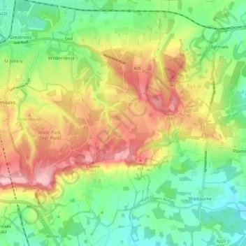
Name: Seal topographic map, elevation, terrain.

Location: Seal, Sevenoaks, Kent, England, United Kingdom (51.23223 0.20581 51.30022 0.26523)

Average elevation: 384 ft

Minimum elevation: 141 ft

Maximum elevation: 715 ft

Other topographic maps

Click on a map to view its topography, its elevation and its terrain.

Seal Chart

United Kingdom > England > Kent > Sevenoaks > Styants Bottom

Average elevation: 469 ft

Knockholt Pound

United Kingdom > England > Kent > Sevenoaks

Average elevation: 554 ft

Godden Green

United Kingdom > England > Kent > Sevenoaks

Average elevation: 472 ft

Halstead

United Kingdom > England > Kent > Sevenoaks

Average elevation: 512 ft

Ash

United Kingdom > England > Kent > Sevenoaks

Average elevation: 456 ft

Bough Beech Reservoir

United Kingdom > England > Kent > Sevenoaks

Average elevation: 256 ft

South Darenth

United Kingdom > England > Kent > Sevenoaks

Average elevation: 164 ft

Heaverham

United Kingdom > England > Kent > Sevenoaks

Average elevation: 466 ft

Knatts Valley

United Kingdom > England > Kent > Sevenoaks > East Hill > Knockmill

Average elevation: 558 ft

Lett's Green

United Kingdom > England > Kent > Sevenoaks > Knockholt

Average elevation: 600 ft

Hosey Hill

United Kingdom > England > Kent > Sevenoaks

Average elevation: 495 ft

Badger's Mount

United Kingdom > England > Kent > Sevenoaks

Average elevation: 453 ft

Sundridge

United Kingdom > England > Kent > Sevenoaks

Average elevation: 381 ft

Horseshoe Green

United Kingdom > England > Kent > Sevenoaks > Markbeech

Average elevation: 282 ft

Toy's Hill

United Kingdom > England > Kent > Sevenoaks

Average elevation: 522 ft

Betsom's Hill

United Kingdom > England > Kent > Sevenoaks

Average elevation: 623 ft

Chiddingstone Hoath

United Kingdom > England > Kent > Sevenoaks

Average elevation: 246 ft

Ide Hill

United Kingdom > England > Kent > Sevenoaks

Average elevation: 495 ft

Chevening

United Kingdom > England > Kent > Sevenoaks

Average elevation: 413 ft

Broke Hill Golf Club

United Kingdom > England > Kent > Sevenoaks > Halstead

Average elevation: 479 ft

Bore Place

United Kingdom > England > Kent > Sevenoaks > Chiddingstone

Average elevation: 249 ft

Weardale

United Kingdom > England > Kent > Sevenoaks > French Street

Average elevation: 561 ft

Crockham Hill

United Kingdom > England > Kent > Sevenoaks

Average elevation: 387 ft

Horton Kirby

United Kingdom > England > Kent > Sevenoaks

Average elevation: 207 ft

Hill Hoath

United Kingdom > England > Kent > Sevenoaks > Hill Hoath

Average elevation: 194 ft

Four Elms

United Kingdom > England > Kent > Sevenoaks

Average elevation: 220 ft

Fawkham Green

United Kingdom > England > Kent > Sevenoaks

Average elevation: 410 ft

Sundridge

United Kingdom > England > Kent > Sevenoaks

Average elevation: 381 ft

Ridley

United Kingdom > England > Kent > Sevenoaks > Hodsoll Street

Average elevation: 479 ft

New Ash Green

United Kingdom > England > Kent > Sevenoaks

Average elevation: 404 ft

Gear up for your next adventure:

📚Navigation Handbooks - Master the art of reading topographic maps and using a compass
📷Action Camera - Capture your outdoor adventures in HD
📌Outdoor GPS Map App - Apps and devices for digital topographic navigation
🦺Reflective Outdoor Gear - Safety gear for low‑light conditions
🗻Climbing Gear Basics - Essential gear for beginner climbers

As an Amazon Associate, this site earns from qualifying purchases at no extra cost to you.