
Market Warsop topographic map
Click on the map to display elevation.
About this map
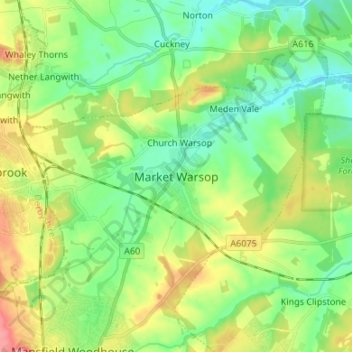
Name: Market Warsop topographic map, elevation, terrain.
Average elevation: 259 ft
Minimum elevation: 138 ft
Maximum elevation: 489 ft
Other topographic maps
Click on a map to view its topography, its elevation and its terrain.
Sutton in Ashfield
United Kingdom > England > Nottinghamshire > Ashfield > Stanton Hill
Average elevation: 505 ft
Kelham CP
United Kingdom > England > Nottinghamshire > Newark and Sherwood > Newark on Trent
Average elevation: 75 ft
Manor House Pond
United Kingdom > England > Nottinghamshire > Broxtowe > Bramcote
Average elevation: 187 ft
Sutton Lawn
United Kingdom > England > Nottinghamshire > Ashfield > Sutton-in-Ashfield
Average elevation: 509 ft
Southwell CP
United Kingdom > England > Nottinghamshire > Newark and Sherwood
Average elevation: 154 ft
Barton in Fabis
United Kingdom > England > Nottinghamshire > Rushcliffe > Barton-in-Fabis
Average elevation: 128 ft
Sherwood Forest NNR
United Kingdom > England > Nottinghamshire > Newark and Sherwood > Ollerton
Average elevation: 233 ft
South Clifton
United Kingdom > England > Nottinghamshire > Newark and Sherwood
Average elevation: 26 ft
Normanton on the Wolds
United Kingdom > England > Nottinghamshire > Rushcliffe
Average elevation: 194 ft
Rolleston CP
United Kingdom > England > Nottinghamshire > Newark and Sherwood
Average elevation: 52 ft
Beckingham
United Kingdom > England > Nottinghamshire > Bassetlaw > Beckingham
Average elevation: 56 ft
Balderton
United Kingdom > England > Nottinghamshire > Newark and Sherwood > Balderton
Average elevation: 66 ft
Egmanton CP
United Kingdom > England > Nottinghamshire > Newark and Sherwood
Average elevation: 164 ft
Epperstone CP
United Kingdom > England > Nottinghamshire > Newark and Sherwood
The report notes Epperstone's "very distinctive character... a combination of topography, buildings, trees and walls.... The constantly changing views make it an attractive space to move through." It also notes, "The approach to the village from the west is along a tunnel formed by overhanging trees, including…
Average elevation: 226 ft
Bilsthorpe CP
United Kingdom > England > Nottinghamshire > Newark and Sherwood
Average elevation: 246 ft
Woodthorpe Grange Park
United Kingdom > England > Nottinghamshire > Nottingham > Arnold
Average elevation: 285 ft
Staythorpe CP
United Kingdom > England > Nottinghamshire > Newark and Sherwood
The land is very low-lying and level, varying little in elevation between 12–14 metres (39–46 ft) throughout.
Average elevation: 52 ft
Nottingham Canal
United Kingdom > England > Nottinghamshire > Nottingham > Beeston
Average elevation: 108 ft
Willoughby on the Wolds
United Kingdom > England > Nottinghamshire > Rushcliffe
Average elevation: 302 ft
River Meden
United Kingdom > England > Nottinghamshire > Mansfield > Warsop Vale
Average elevation: 233 ft
Gonalston CP
United Kingdom > England > Nottinghamshire > Newark and Sherwood
Average elevation: 138 ft
Archers Lake
United Kingdom > England > Nottinghamshire > Rushcliffe > Bingham
Average elevation: 92 ft
Collingham CP
United Kingdom > England > Nottinghamshire > Newark and Sherwood
Average elevation: 49 ft
Sherwood Forest National Nature Reserve
United Kingdom > England > Nottinghamshire > Newark and Sherwood > Ollerton
Average elevation: 233 ft
Elton-on-the-Hill
United Kingdom > England > Nottinghamshire > Rushcliffe
Elton lies about 14 miles (23 km) east of Nottingham. It straddles the A52 trunk road, from which Station Road runs north towards Orston and Sutton Lane south, with Sutton-cum-Granby being the nearest hamlet in that direction. Elton has a population of 114 people and is in the Rushcliffe district. It has an…
Average elevation: 95 ft
Clipston
United Kingdom > England > Nottinghamshire > Rushcliffe
Clipston stands on the northernmost edge of the Wolds in Nottinghamshire. The area enjoys, from an elevation of about 79 m/259 ft, panoramic views of the Trent valley and the East and South side of the city of Nottingham, some 50 m/164 ft lower. Nearby to the west is Hoe Hill, with a horseshoe-shaped wood.
Average elevation: 194 ft
Edingley CP
United Kingdom > England > Nottinghamshire > Newark and Sherwood
Average elevation: 207 ft
Hockerton CP
United Kingdom > England > Nottinghamshire > Newark and Sherwood
Average elevation: 177 ft
North Muskham CP
United Kingdom > England > Nottinghamshire > Newark and Sherwood
Average elevation: 36 ft
Newark
United Kingdom > England > Nottinghamshire > Newark and Sherwood > Newark on Trent
Average elevation: 56 ft