Geolocate

Burutu topographic map

Click on the map to display elevation.

About this map

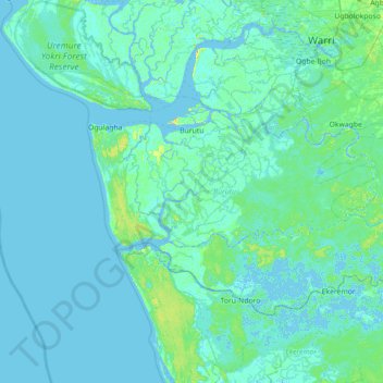
Name: Burutu topographic map, elevation, terrain.

Location: Burutu, Delta State, Nigeria (5.01120 5.20576 5.46767 5.91544)

Average elevation: 7 ft

Minimum elevation: -20 ft

Maximum elevation: 75 ft

Other topographic maps

Click on a map to view its topography, its elevation and its terrain.

Lagos Creek

Nigeria > Delta State > Warri North

Average elevation: 7 ft

Alders Town

Nigeria > Delta State

Average elevation: 10 ft

Jeddo

Nigeria > Delta State > Okpe

Average elevation: 10 ft

Eroghor

Nigeria > Delta State

Average elevation: 7 ft

Awah

Nigeria > Delta State > Ndokwa East

Average elevation: 39 ft

Ogwashi-Uku

Nigeria > Delta State > Aniocha South

Average elevation: 512 ft

Owa-Alero

Nigeria > Delta State > Ika North East

Average elevation: 554 ft

Agbor

Nigeria > Delta State > Ika South

Average elevation: 525 ft

Issele Uku

Nigeria > Delta State > Aniocha North

Average elevation: 853 ft

Ekurede-itsekiri

Nigeria > Delta State

Average elevation: 10 ft

Abavo

Nigeria > Delta State > Ika South

Average elevation: 486 ft

Kwale

Nigeria > Delta State > Ndokwa West

Average elevation: 52 ft

Idumuesah

Nigeria > Delta State > Ika North East

Average elevation: 518 ft

Asaba

Nigeria > Delta State > Oshimili South

Average elevation: 203 ft

Escravos River

Nigeria > Delta State > Warri South-West

Average elevation: 7 ft

Gear up for your next adventure:

🧦Merino Wool Socks - Moisture-wicking, blister-preventing socks for long treks
📷Action Camera - Capture your outdoor adventures in HD
🔪Outdoor Multitools - Essential survival tools for gear repair and field use
🧤Hiking Gloves - Protective gloves for rugged trails
🗺️Topographic Maps - Detailed topo maps for hiking, exploring and outdoor navigation

As an Amazon Associate, this site earns from qualifying purchases at no extra cost to you.