
Make a donation
Gear up for your next adventure:
As an Amazon Associate, this site earns from qualifying purchases at no extra cost to you.
Corral topographic map
Click on the map to display elevation.
Make a donation
Gear up for your next adventure:
As an Amazon Associate, this site earns from qualifying purchases at no extra cost to you.
About this map
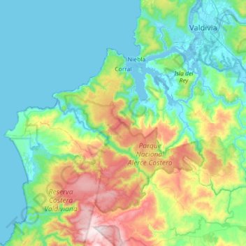
Name: Corral topographic map, elevation, terrain.
Location: Corral, Provincia de Valdivia, Región de Los Ríos, Chile (-40.11632 -73.70728 -39.85126 -73.13842)
Average elevation: 761 ft
Minimum elevation: -7 ft
Maximum elevation: 3,399 ft
Make a donation
Gear up for your next adventure:
As an Amazon Associate, this site earns from qualifying purchases at no extra cost to you.
Other topographic maps
Click on a map to view its topography, its elevation and its terrain.
Estación Experimental Fundo San Martín
Chile > Región de Los Ríos > Provincia de Valdivia > Mariquina
Average elevation: 105 ft
Make a donation
Gear up for your next adventure:
As an Amazon Associate, this site earns from qualifying purchases at no extra cost to you.
Parque Municipal Guillermo Harnecker
Chile > Región de Los Ríos > Provincia de Valdivia > Valdivia > Villa Endesa
Average elevation: 26 ft
San José de La Mariquina
Chile > Región de Los Ríos > Provincia de Valdivia > Mariquina
Average elevation: 105 ft
Make a donation
Gear up for your next adventure:
As an Amazon Associate, this site earns from qualifying purchases at no extra cost to you.
Puerto Fuy
Chile > Región de Los Ríos > Provincia de Valdivia > Panguipulli
Average elevation: 2,251 ft
Make a donation
Gear up for your next adventure:
As an Amazon Associate, this site earns from qualifying purchases at no extra cost to you.
Volcán Mocho
Chile > Región de Los Ríos > Provincia de Valdivia > Los Lagos
Average elevation: 6,781 ft
Make a donation
Gear up for your next adventure:
As an Amazon Associate, this site earns from qualifying purchases at no extra cost to you.
Misisipi
Chile > Región de Los Ríos > Provincia de Valdivia > Mariquina > Mehuín
Average elevation: 141 ft
Villa California
Chile > Región de Los Ríos > Provincia de Valdivia > Valdivia
Average elevation: 89 ft
Panguipulli
Chile > Región de Los Ríos > Provincia de Valdivia > Panguipulli > Panguipulli
Average elevation: 741 ft
Make a donation
Gear up for your next adventure:
As an Amazon Associate, this site earns from qualifying purchases at no extra cost to you.
Pichidollinco
Chile > Región de Los Ríos > Provincia de Valdivia > Panguipulli > Pichidollinco
Average elevation: 988 ft
Huichaco
Chile > Región de Los Ríos > Provincia de Valdivia > Máfil > Huichaco
Average elevation: 528 ft
Los Molinos
Chile > Región de Los Ríos > Provincia de Valdivia > Los Lagos > Los Molinos
Average elevation: 974 ft
Villa Endesa
Chile > Región de Los Ríos > Provincia de Valdivia > Valdivia > Villa Endesa
Average elevation: 26 ft
Make a donation
Gear up for your next adventure:
As an Amazon Associate, this site earns from qualifying purchases at no extra cost to you.
Cutipay
Chile > Región de Los Ríos > Provincia de Valdivia > Valdivia > Cutipay
Average elevation: 115 ft
Puringue Los Ciruelos
Chile > Región de Los Ríos > Provincia de Valdivia > Mariquina > Puringue Los Ciruelos
Average elevation: 230 ft
Puringue Pobre
Chile > Región de Los Ríos > Provincia de Valdivia > Mariquina > Puringue Pobre
Average elevation: 95 ft
Make a donation
Gear up for your next adventure:
As an Amazon Associate, this site earns from qualifying purchases at no extra cost to you.
Make a donation
Gear up for your next adventure:
As an Amazon Associate, this site earns from qualifying purchases at no extra cost to you.
Make a donation
Gear up for your next adventure:
As an Amazon Associate, this site earns from qualifying purchases at no extra cost to you.
Parque Oncol
Chile > Región de Los Ríos > Provincia de Valdivia > Valdivia
Ocupa el costado sur del cerro Oncol junto al santuario de la naturaleza Carlos Anwandter del río Cruces. La cima del cerro alcanza una altitud de 715 m s. n. m., y se encuentra a solo 5 kilómetros de la costa.
Average elevation: 1,207 ft
Comunidad Dionisio Manguel Chepo
Chile > Región de Los Ríos > Provincia de Valdivia > Los Lagos
Average elevation: 978 ft
Make a donation
Gear up for your next adventure:
As an Amazon Associate, this site earns from qualifying purchases at no extra cost to you.
Humedal Equil
Chile > Región de Los Ríos > Provincia de Valdivia > Los Lagos
Average elevation: 233 ft