
Make a donation
Gear up for your next adventure:
As an Amazon Associate, this site earns from qualifying purchases at no extra cost to you.
Faimes topographic map
Click on the map to display elevation.
Make a donation
Gear up for your next adventure:
As an Amazon Associate, this site earns from qualifying purchases at no extra cost to you.
About this map
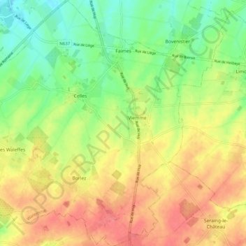
Name: Faimes topographic map, elevation, terrain.
Location: Faimes, Waremme, Liège, Wallonie, 4317, Belgique (50.61575 5.19223 50.67797 5.28676)
Average elevation: 499 ft
Minimum elevation: 390 ft
Maximum elevation: 607 ft
Make a donation
Gear up for your next adventure:
As an Amazon Associate, this site earns from qualifying purchases at no extra cost to you.
Other topographic maps
Click on a map to view its topography, its elevation and its terrain.
Make a donation
Gear up for your next adventure:
As an Amazon Associate, this site earns from qualifying purchases at no extra cost to you.
Make a donation
Gear up for your next adventure:
As an Amazon Associate, this site earns from qualifying purchases at no extra cost to you.
Make a donation
Gear up for your next adventure:
As an Amazon Associate, this site earns from qualifying purchases at no extra cost to you.
Saint-Georges-sur-Meuse
Belgique > Liège > Waremme > Saint-Georges-sur-Meuse
Le territoire de la commune se situe en Hesbaye liégeoise. La Meuse marque la limite sud au niveau du hameau de La Mallieue (altitude : 70 m). Entre ce hameau et Stockay, se trouve le versant nord de la Meuse, cadre d'importantes carrières d'extraction. Le reste de la commune occupe le plateau hesbignon…
Average elevation: 587 ft
Make a donation
Gear up for your next adventure:
As an Amazon Associate, this site earns from qualifying purchases at no extra cost to you.
Make a donation
Gear up for your next adventure:
As an Amazon Associate, this site earns from qualifying purchases at no extra cost to you.
Make a donation
Gear up for your next adventure:
As an Amazon Associate, this site earns from qualifying purchases at no extra cost to you.
Make a donation
Gear up for your next adventure:
As an Amazon Associate, this site earns from qualifying purchases at no extra cost to you.
Make a donation
Gear up for your next adventure:
As an Amazon Associate, this site earns from qualifying purchases at no extra cost to you.
Otrange
Le territoire d'Otrange appartenant par le versant nord du Geer au bassin hydrographique de la Meuse présente une déclivité assez régulière du nord vers le sud. Le point culminant (132 m d'altitude) est au nord-ouest, sur la chaussée romaine, près de la chapelle St-Eloi, du côté du lieu-dit Palimont.…
Average elevation: 364 ft
Make a donation
Gear up for your next adventure:
As an Amazon Associate, this site earns from qualifying purchases at no extra cost to you.
Make a donation
Gear up for your next adventure:
As an Amazon Associate, this site earns from qualifying purchases at no extra cost to you.
Make a donation
Gear up for your next adventure:
As an Amazon Associate, this site earns from qualifying purchases at no extra cost to you.
Make a donation
Gear up for your next adventure:
As an Amazon Associate, this site earns from qualifying purchases at no extra cost to you.
Crisnée
Belgique > Liège > Waremme > Crisnée
Le point culminant du village, à environ 134 mètres d'altitude, se trouve à l'extrême nord-est, près de la Tombe (dite de Herstappe, et qui se trouve en fait sur le territoire de Lowaige), et du haut de laquelle, on aperçoit un quarteron de clochers, les tours de la Basilique Notre-Dame de Tongres et,…
Average elevation: 404 ft
Make a donation
Gear up for your next adventure:
As an Amazon Associate, this site earns from qualifying purchases at no extra cost to you.