
Make a donation
Gear up for your next adventure:
As an Amazon Associate, this site earns from qualifying purchases at no extra cost to you.
Toacaso topographic map
Click on the map to display elevation.
Make a donation
Gear up for your next adventure:
As an Amazon Associate, this site earns from qualifying purchases at no extra cost to you.
About this map
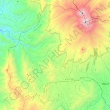
Name: Toacaso topographic map, elevation, terrain.
Location: Toacaso, Latacunga, Cotopaxi, Ecuador (-0.79116 -78.83622 -0.63580 -78.66856)
Average elevation: 11,654 ft
Minimum elevation: 8,376 ft
Maximum elevation: 17,077 ft
Make a donation
Gear up for your next adventure:
As an Amazon Associate, this site earns from qualifying purchases at no extra cost to you.
Other topographic maps
Click on a map to view its topography, its elevation and its terrain.
Latacunga
Ecuador > Cotopaxi > Latacunga > Latacunga
Latacunga, también conocida como San Vicente Mártir de Latacunga, es una ciudad ecuatoriana; cabecera cantonal del Cantón Latacunga y capital de la Provincia de Cotopaxi, así como la urbe más grande y poblada de la misma. Se localiza al centro-norte de la Región interandina del Ecuador, en la hoya del…
Average elevation: 10,541 ft
Make a donation
Gear up for your next adventure:
As an Amazon Associate, this site earns from qualifying purchases at no extra cost to you.
Make a donation
Gear up for your next adventure:
As an Amazon Associate, this site earns from qualifying purchases at no extra cost to you.
Make a donation
Gear up for your next adventure:
As an Amazon Associate, this site earns from qualifying purchases at no extra cost to you.
SanPedro de Teneria
Ecuador > Cotopaxi > Latacunga > San Juan de Pastocalle
Average elevation: 10,781 ft
Make a donation
Gear up for your next adventure:
As an Amazon Associate, this site earns from qualifying purchases at no extra cost to you.
Make a donation
Gear up for your next adventure:
As an Amazon Associate, this site earns from qualifying purchases at no extra cost to you.
Make a donation
Gear up for your next adventure:
As an Amazon Associate, this site earns from qualifying purchases at no extra cost to you.
Make a donation
Gear up for your next adventure:
As an Amazon Associate, this site earns from qualifying purchases at no extra cost to you.
Make a donation
Gear up for your next adventure:
As an Amazon Associate, this site earns from qualifying purchases at no extra cost to you.
Make a donation
Gear up for your next adventure:
As an Amazon Associate, this site earns from qualifying purchases at no extra cost to you.
Ignacio Flores
Ecuador > Cotopaxi > Latacunga > Latacunga > Ignacio Flores
Average elevation: 9,272 ft
Make a donation
Gear up for your next adventure:
As an Amazon Associate, this site earns from qualifying purchases at no extra cost to you.
Zumbalica Sur
Ecuador > Cotopaxi > Latacunga > Latacunga > La Calera Sur > Zumbalica Sur
Average elevation: 9,331 ft
Make a donation
Gear up for your next adventure:
As an Amazon Associate, this site earns from qualifying purchases at no extra cost to you.
Make a donation
Gear up for your next adventure:
As an Amazon Associate, this site earns from qualifying purchases at no extra cost to you.