
Make a donation
Gear up for your next adventure:
As an Amazon Associate, this site earns from qualifying purchases at no extra cost to you.
双峰县 topographic map
Click on the map to display elevation.
Make a donation
Gear up for your next adventure:
As an Amazon Associate, this site earns from qualifying purchases at no extra cost to you.
About this map
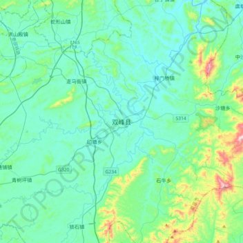
Name: 双峰县 topographic map, elevation, terrain.
Location: 双峰县, 娄底市, 湖南省, 中国 (27.29838 112.01035 27.61838 112.33035)
Average elevation: 554 ft
Minimum elevation: 203 ft
Maximum elevation: 2,454 ft
Make a donation
Gear up for your next adventure:
As an Amazon Associate, this site earns from qualifying purchases at no extra cost to you.
Other topographic maps
Click on a map to view its topography, its elevation and its terrain.
长沙市
长沙的北、西、南缘为山地,东南以丘陵为主,东北以岗地为主;山地、丘陵、岗地、平原大体各占四分之一。长沙东有连云山、大围山、九岭山等呈东北~西南走向作雁行状排列,海拔800米以上山峰有50多座,浏阳大围山七星岭海拔1607.9米,为辖区最高点;长沙西有海拔800米以上的山峰13座,乔口镇湛湖海拔23.5米,为辖区最低点,海拔相差1584.4米。 长江一级支流湘江为长沙最重要的河流,由南向北贯穿全境,境内长度约75公里,把城市分为河东和河西两大部分。海拔300.08米的岳麓山伫立于湘江西岸,长5千米的冲击沙洲橘子洲卧于江心,一起构成了长沙“山水洲城”的地貌特色。
Average elevation: 591 ft
Make a donation
Gear up for your next adventure:
As an Amazon Associate, this site earns from qualifying purchases at no extra cost to you.
衡阳市
衡阳处于凹形面轴带部分,周围环绕着古老宕层形成的断续环带的岭脊山地,衡阳市内镶大面积白垩系和下第三系红层的红色丘陵台地,构成典型的盆地形势。衡阳盆地南高北低。盆地南面地势较高,1000米以上的山中东西连绵数十公里;盆地北面相对偏低,衡山山脉虽较高,但各峰呈峰林状屹立于中间,其东西两侧都有较低的低的向北通道,其东侧的湘江河谷两岸海拔高度均在100米以下。整个地形由西南向东北复合倾斜,而盆地由四周向中部降低,呈现1000米、800-700米、400-300米、150米四级夷为平面。四周山丘围绕,中部平岗丘交错。东部为罗霄山余脉天光山、四方山、园明坳;南部为南岭余脉塔山、大义山、天门仙、景峰坳;西部为越城岭的延伸熊罴岭、…
Average elevation: 673 ft
Make a donation
Gear up for your next adventure:
As an Amazon Associate, this site earns from qualifying purchases at no extra cost to you.
岳阳市
岳阳市东部是山丘地带,以平江县山地、丘陵面积最大,占全县总面积五分之四以上。连云山海拔1600.3米,为全市最高点。连云山北部为幕阜山,绵亘五百余里,海拔1595.6米。属于幕阜、连云两大山脉的还有临湘与岳阳毗邻的药姑山、相思山、大云山,平江与汨罗交界的智丰山、玉池山等,群山起伏,逶迤西下,至中部形成坡度和缓,海拔均在300米以下的丘陵和岗地。西部是坦荡的滨湖平原,其中华容、湘阴二县平原面积最广。这一带地势低平,海拔在50米以下。临湘谷花洲,海拔仅23米,为全市最低点。全市整个地势由东往西逐级降低,呈阶梯状向洞庭湖平原倾斜。
Average elevation: 459 ft
Make a donation
Gear up for your next adventure:
As an Amazon Associate, this site earns from qualifying purchases at no extra cost to you.
临湘市
由于明清以来,江西移民的大量迁入,临湘方言被划分为赣语大通片,县域北部靠近长江,老县治陆城(民国以前)就在长江岸边,水路发达,迁客骚人多会于此,南部多山,受地形影响从北向南,临湘话演变为了目前的路北、路中、路南三种语调,另:清代以来,由于湖北沔阳(今仙桃)地区移民大量汇入,路北方言受到西南官话冲击。特别是江南镇、黄盖湖镇基本为江北移民,流行西南官话,与长江对岸的湖北洪湖话一致;1949年以后,沿江地区有大量来自益阳等湖南省内地区的农垦移民。 由于移民构成,临湘兼有湖湘文化、赣文化、荆楚文化的特色交融。从史迹来看,临湘乃至岳阳县地区的大多数居民都为江西北部移民,至今方言仍有相通之处,移民时间则集中在明清二代。
Average elevation: 374 ft
Make a donation
Gear up for your next adventure:
As an Amazon Associate, this site earns from qualifying purchases at no extra cost to you.
Make a donation
Gear up for your next adventure:
As an Amazon Associate, this site earns from qualifying purchases at no extra cost to you.
Make a donation
Gear up for your next adventure:
As an Amazon Associate, this site earns from qualifying purchases at no extra cost to you.
Make a donation
Gear up for your next adventure:
As an Amazon Associate, this site earns from qualifying purchases at no extra cost to you.
Make a donation
Gear up for your next adventure:
As an Amazon Associate, this site earns from qualifying purchases at no extra cost to you.
Make a donation
Gear up for your next adventure:
As an Amazon Associate, this site earns from qualifying purchases at no extra cost to you.
湘西土家族苗族自治州
地理上处云贵高原北东侧与鄂西山地南西端之结合部,武陵山脉由东北向西南斜贯全境,地势南东低、北西高,属中国由西向东逐步降低第二阶梯之东缘。西部与云贵高原相连,北部与鄂西山地交颈,东南以雪峰山为屏障,武陵山脉蜿蜒于境内。地势由西北向东南倾斜,平均海拨800-1200米,西北边境龙山县的大灵山海拨1736.5米,为境内最高点;泸溪县上堡乡大龙溪出口河床海拔97.1米,为境内最低点。西南石灰岩分布极广,岩溶发育充分,多溶洞、伏流;西北石英砂岩密布,因地壳作用形成小片峰,以花垣排吾乡周围最为典型。东西部为低山丘陵区,平均海拔200-500米,溪河纵横其间,两岸多冲积平原。地貌形态的总体轮廓以山原山地为主,兼有丘陵和小平原,并…
Average elevation: 1,795 ft
Make a donation
Gear up for your next adventure:
As an Amazon Associate, this site earns from qualifying purchases at no extra cost to you.
Make a donation
Gear up for your next adventure:
As an Amazon Associate, this site earns from qualifying purchases at no extra cost to you.
石门县
石门,自南北朝置石门郡始,已有1400多年的历史。县名来历传说不一,主要有三:一曰:县城以东二里处两岩壁立如门;一曰:县城以西三里地杨岭岗与新街口附近之石山,隔河对峙似门;一曰:县城以东15里处有岩门口。三者虽方位、距离不同,但俱说明系地形特征而得名。县城古为荆楚之地,秦隶黔中郡慈姑县,汉属武陵郡零阳县,三国吴永安六年改隶天门郡,晋属天门郡澧阳县(西北部曾置渠阳县),南北朝时天门郡治由大庸县境下迁石门,陈武帝永定二年(公元558年),后梁肖察(即皇帝位于江陵之后)罢天门郡,更置石门郡,隋文帝开皇九年(公元589年),废石门郡,建石门县,划归澧州管辖。此后,虽隶属有变,而县名未易。
Average elevation: 1,335 ft
Make a donation
Gear up for your next adventure:
As an Amazon Associate, this site earns from qualifying purchases at no extra cost to you.
Make a donation
Gear up for your next adventure:
As an Amazon Associate, this site earns from qualifying purchases at no extra cost to you.
Make a donation
Gear up for your next adventure:
As an Amazon Associate, this site earns from qualifying purchases at no extra cost to you.
Make a donation
Gear up for your next adventure:
As an Amazon Associate, this site earns from qualifying purchases at no extra cost to you.
Make a donation
Gear up for your next adventure:
As an Amazon Associate, this site earns from qualifying purchases at no extra cost to you.
Make a donation
Gear up for your next adventure:
As an Amazon Associate, this site earns from qualifying purchases at no extra cost to you.
Make a donation
Gear up for your next adventure:
As an Amazon Associate, this site earns from qualifying purchases at no extra cost to you.
Make a donation
Gear up for your next adventure:
As an Amazon Associate, this site earns from qualifying purchases at no extra cost to you.
Make a donation
Gear up for your next adventure:
As an Amazon Associate, this site earns from qualifying purchases at no extra cost to you.
新晃侗族自治县
新晃侗族自治县的主要地貌是山地。东南、西南和北部地势高,东北地势低,位于云贵高原苗岭山脉余脉延伸末端,雪峰山脉以西,武陵山脉以南,是中国第二阶梯到第三阶梯过渡地带。新晃侗族自治县海拔一般是400米至800米之间,东南部最高点天雷山海拔1136.3米,连接1000米以上的山峰14座,形成了东南屏障。西南部美岩破海拔1101.5米,连接海拔1000米以上的山峰11座。北部武陵山余脉缓缓下降到㵲阳河,波洲镇江口村是新晃侗族自治县最低点,海拔只有287.7米,因这里属溪水平原、灰岩岗地分布区,历代都是政治、经济、文化、交通中心。
Average elevation: 1,900 ft
Make a donation
Gear up for your next adventure:
As an Amazon Associate, this site earns from qualifying purchases at no extra cost to you.
Make a donation
Gear up for your next adventure:
As an Amazon Associate, this site earns from qualifying purchases at no extra cost to you.
Make a donation
Gear up for your next adventure:
As an Amazon Associate, this site earns from qualifying purchases at no extra cost to you.
安化县
安化县位于雪峰山脉北段,资水中游,几乎处于湖南省的中心位置。东与桃江县、宁乡市相邻,南与涟源市、新化县接壤,西与溆浦县、沅陵县交界,北与桃源县、常德市鼎城区毗邻。面积4950.25平方公里,是湖南省第三大县。全县人口97.2万人。资水流过全县,在资水柘溪段建有湖南第一座大型水电站——柘溪电站,并形成柘溪水库境,库区水面达85平方公里。全县境内干流长度大于5公里的溪河有170条,包括洢水、柳溪等。县内多高山,山地占全县总面积的82%,海拔1000米以上的山峰有63座。县城东坪镇距省会长沙240公里。安化属于亚热带季风气候区,年平均气温16.2摄氏度至17.6摄氏度,降水1706.1毫米,无霜期长达275天,平均日照1…
Average elevation: 1,112 ft
Make a donation
Gear up for your next adventure:
As an Amazon Associate, this site earns from qualifying purchases at no extra cost to you.
Make a donation
Gear up for your next adventure:
As an Amazon Associate, this site earns from qualifying purchases at no extra cost to you.