
Make a donation
Gear up for your next adventure:
As an Amazon Associate, this site earns from qualifying purchases at no extra cost to you.
鹤城区 topographic map
Click on the map to display elevation.
Make a donation
Gear up for your next adventure:
As an Amazon Associate, this site earns from qualifying purchases at no extra cost to you.
About this map
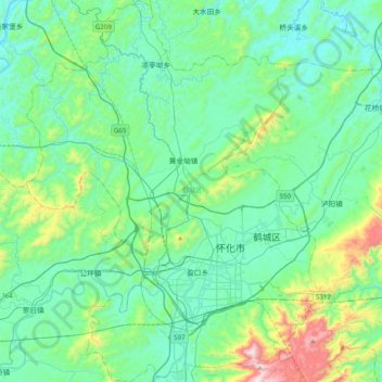
Name: 鹤城区 topographic map, elevation, terrain.
Location: 鹤城区, 怀化市, 湖南省, 中国 (27.44706 109.78465 27.79889 110.14086)
Average elevation: 1,099 ft
Minimum elevation: 495 ft
Maximum elevation: 3,734 ft
Make a donation
Gear up for your next adventure:
As an Amazon Associate, this site earns from qualifying purchases at no extra cost to you.
Other topographic maps
Click on a map to view its topography, its elevation and its terrain.
长沙市
长沙的北、西、南缘为山地,东南以丘陵为主,东北以岗地为主;山地、丘陵、岗地、平原大体各占四分之一。长沙东有连云山、大围山、九岭山等呈东北~西南走向作雁行状排列,海拔800米以上山峰有50多座,浏阳大围山七星岭海拔1607.9米,为辖区最高点;长沙西有海拔800米以上的山峰13座,乔口镇湛湖海拔23.5米,为辖区最低点,海拔相差1584.4米。 长江一级支流湘江为长沙最重要的河流,由南向北贯穿全境,境内长度约75公里,把城市分为河东和河西两大部分。海拔300.08米的岳麓山伫立于湘江西岸,长5千米的冲击沙洲橘子洲卧于江心,一起构成了长沙“山水洲城”的地貌特色。
Average elevation: 187 ft
Make a donation
Gear up for your next adventure:
As an Amazon Associate, this site earns from qualifying purchases at no extra cost to you.
郴州市
郴州市属于亚热带季风气候,大陆性较强。四季分明,平地丘陵区的冬夏季长而春秋季短。山区则冬季长,而春、夏、秋季短。平地丘陵区,由冬入春和由春入夏,则南方早于北方2—4天。市区多年平均于3月上旬入春,5月上旬入夏,9月底10月初入秋,11月底12月初入冬。春季降水量是一年最多的季节,占全年降水量的37.3%。日照时数220—290小时,日照时数呈南少北多的分布特征。春季气候最显著的特征是开春早,气温回升快,降水丰沛,多阴雨及冰雹大风。夏季气候炎热,易发生盛夏干旱,也易出现暴雨洪涝,由于平均海拔高度在400米以上,因而丘陵区和山地与相邻市相比,透出凉爽的特点。山区的凉爽气候特征则更加突出。郴州市的秋季主要是以秋高气爽天气…
Average elevation: 1,194 ft
Make a donation
Gear up for your next adventure:
As an Amazon Associate, this site earns from qualifying purchases at no extra cost to you.
Make a donation
Gear up for your next adventure:
As an Amazon Associate, this site earns from qualifying purchases at no extra cost to you.
湘西州
地理上处云贵高原北东侧与鄂西山地南西端之结合部,武陵山脉由东北向西南斜贯全境,地势南东低、北西高,属中国由西向东逐步降低第二阶梯之东缘。西部与云贵高原相连,北部与鄂西山地交颈,东南以雪峰山为屏障,武陵山脉蜿蜒于境内。地势由西北向东南倾斜,平均海拨800-1200米,西北边境龙山县的大灵山海拨1736.5米,为境内最高点;泸溪县上堡乡大龙溪出口河床海拔97.1米,为境内最低点。西南石灰岩分布极广,岩溶发育充分,多溶洞、伏流;西北石英砂岩密布,因地壳作用形成小片峰,以花垣排吾乡周围最为典型。东西部为低山丘陵区,平均海拔200-500米,溪河纵横其间,两岸多冲积平原。地貌形态的总体轮廓以山原山地为主,兼有丘陵和小平原,并…
Average elevation: 1,778 ft
Make a donation
Gear up for your next adventure:
As an Amazon Associate, this site earns from qualifying purchases at no extra cost to you.
Make a donation
Gear up for your next adventure:
As an Amazon Associate, this site earns from qualifying purchases at no extra cost to you.
Make a donation
Gear up for your next adventure:
As an Amazon Associate, this site earns from qualifying purchases at no extra cost to you.
Make a donation
Gear up for your next adventure:
As an Amazon Associate, this site earns from qualifying purchases at no extra cost to you.
Make a donation
Gear up for your next adventure:
As an Amazon Associate, this site earns from qualifying purchases at no extra cost to you.
Make a donation
Gear up for your next adventure:
As an Amazon Associate, this site earns from qualifying purchases at no extra cost to you.
Make a donation
Gear up for your next adventure:
As an Amazon Associate, this site earns from qualifying purchases at no extra cost to you.
Make a donation
Gear up for your next adventure:
As an Amazon Associate, this site earns from qualifying purchases at no extra cost to you.
Make a donation
Gear up for your next adventure:
As an Amazon Associate, this site earns from qualifying purchases at no extra cost to you.
Make a donation
Gear up for your next adventure:
As an Amazon Associate, this site earns from qualifying purchases at no extra cost to you.
Make a donation
Gear up for your next adventure:
As an Amazon Associate, this site earns from qualifying purchases at no extra cost to you.
Make a donation
Gear up for your next adventure:
As an Amazon Associate, this site earns from qualifying purchases at no extra cost to you.
Make a donation
Gear up for your next adventure:
As an Amazon Associate, this site earns from qualifying purchases at no extra cost to you.
Make a donation
Gear up for your next adventure:
As an Amazon Associate, this site earns from qualifying purchases at no extra cost to you.
Make a donation
Gear up for your next adventure:
As an Amazon Associate, this site earns from qualifying purchases at no extra cost to you.
Make a donation
Gear up for your next adventure:
As an Amazon Associate, this site earns from qualifying purchases at no extra cost to you.
Make a donation
Gear up for your next adventure:
As an Amazon Associate, this site earns from qualifying purchases at no extra cost to you.
安化县
安化县位于雪峰山脉北段,资水中游,几乎处于湖南省的中心位置。东与桃江县、宁乡市相邻,南与涟源市、新化县接壤,西与溆浦县、沅陵县交界,北与桃源县、常德市鼎城区毗邻。面积4950.25平方公里,是湖南省第三大县。全县人口97.2万人。资水流过全县,在资水柘溪段建有湖南第一座大型水电站——柘溪电站,并形成柘溪水库境,库区水面达85平方公里。全县境内干流长度大于5公里的溪河有170条,包括洢水、柳溪等。县内多高山,山地占全县总面积的82%,海拔1000米以上的山峰有63座。县城东坪镇距省会长沙240公里。安化属于亚热带季风气候区,年平均气温16.2摄氏度至17.6摄氏度,降水1706.1毫米,无霜期长达275天,平均日照1…
Average elevation: 1,339 ft
Make a donation
Gear up for your next adventure:
As an Amazon Associate, this site earns from qualifying purchases at no extra cost to you.
Make a donation
Gear up for your next adventure:
As an Amazon Associate, this site earns from qualifying purchases at no extra cost to you.
Make a donation
Gear up for your next adventure:
As an Amazon Associate, this site earns from qualifying purchases at no extra cost to you.
Make a donation
Gear up for your next adventure:
As an Amazon Associate, this site earns from qualifying purchases at no extra cost to you.
Make a donation
Gear up for your next adventure:
As an Amazon Associate, this site earns from qualifying purchases at no extra cost to you.