
Wild Horse Reservoir topographic map
Interactive map
Click on the map to display elevation.
About this map
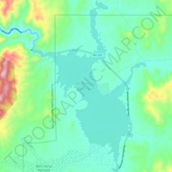
Name: Wild Horse Reservoir topographic map, elevation, terrain.
Location: Wild Horse Reservoir, Elko County, Nevada, United States (41.63102 -115.84590 41.71033 -115.77451)
Average elevation: 6,391 ft
Minimum elevation: 6,086 ft
Maximum elevation: 7,444 ft
Elko County trails, hiking, mountain biking, running and outdoor activities
Other topographic maps
Click on a map to view its topography, its elevation and its terrain.
Zunino Reservoir Dam;Zunino Reservoir
United States > Nevada > Elko County
Average elevation: 5,620 ft
Ruby Mountains
United States > Nevada > Elko County
The Ruby Mountains (Shoshoni: 'Duka Doya', meaning “Snowcapped”) are a mountain range, primarily located within Elko County with a small extension into White Pine County, in Nevada, United States. Most of the range is included within the Humboldt-Toiyabe National Forest. The range reaches a maximum…
Average elevation: 6,437 ft
Angel Lake
United States > Nevada > Elko County
Angel Lake is a glacial tarn in the northern part of the East Humboldt Range, in central Elko County in the northeastern part of the state of Nevada. It is located at approximately 41°01.6′N 115°05.1′W / 41.0267°N 115.0850°W / 41.0267; -115.0850, and at an elevation of 8378 feet (2553 m). It…
Average elevation: 8,766 ft