
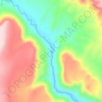
Salmon Falls Creek topographic map
Interactive map
Click on the map to display elevation.
About this map
Name: Salmon Falls Creek topographic map, elevation, terrain.
Location: Salmon Falls Creek, Elko County, Nevada, United States (41.71574 -114.89146 41.74783 -114.86218)
Average elevation: 5,951 ft
Minimum elevation: 5,476 ft
Maximum elevation: 6,476 ft
Other topographic maps
Click on a map to view its topography, its elevation and its terrain.
Elko
United States > Nevada > Elko County
Elko, Elko County, Nevada, 89801, United States
Average elevation: 5,338 ft
Wild Horse Reservoir
United States > Nevada > Elko County
Wild Horse Reservoir, Elko County, Nevada, United States
Average elevation: 6,391 ft
Ruby Valley
United States > Nevada > Elko County
Ruby Valley, Elko County, Nevada, United States
Average elevation: 6,430 ft
Cedar Mountain
United States > Nevada > Elko County
Cedar Mountain, Elko County, Nevada, United States
Average elevation: 6,017 ft
Bald Mountain
United States > Nevada > Elko County
Bald Mountain, Elko County, Nevada, 89831, United States
Average elevation: 6,572 ft
South Fork Reservoir
United States > Nevada > Elko County
South Fork Reservoir, Elko County, Nevada, United States
Average elevation: 5,289 ft
Wilson Reservoir
United States > Nevada > Elko County
Wilson Reservoir, Elko County, Nevada, United States
Average elevation: 5,328 ft
Zunino Reservoir Dam;Zunino Reservoir
United States > Nevada > Elko County
Zunino Reservoir Dam;Zunino Reservoir, Elko County, Nevada, United States
Average elevation: 5,620 ft
Charleston
United States > Nevada > Elko County
Charleston, Elko County, Nevada, United States
Average elevation: 6,283 ft
West Wendover
United States > Nevada > Elko County
West Wendover, Elko County, Nevada, United States
Average elevation: 4,669 ft
Angel Lake
United States > Nevada > Elko County
Angel Lake, Elko County, Nevada, United States
Average elevation: 8,766 ft
Ruby Mountains
United States > Nevada > Elko County
Ruby Mountains, Elko County, Nevada, United States
Average elevation: 6,437 ft
Deadhorse Point
United States > Nevada > Elko County
Deadhorse Point, Elko County, Nevada, United States
Average elevation: 7,090 ft
Spring Creek
United States > Nevada > Elko County
Spring Creek, Elko County, Nevada, United States
Average elevation: 5,646 ft
Carlin
United States > Nevada > Elko County
Carlin, Elko County, Nevada, 89822, United States
Average elevation: 4,993 ft
Montello
United States > Nevada > Elko County > Montello
Montello, Elko County, Nevada, 89830, United States
Average elevation: 4,898 ft
Mountain City
United States > Nevada > Elko County
Mountain City, Elko County, Nevada, 89813, United States
Average elevation: 5,906 ft
Contact
United States > Nevada > Elko County
Contact, Elko County, Nevada, United States
Average elevation: 5,568 ft
Jackpot
United States > Nevada > Elko County
Jackpot, Elko County, Nevada, 89825, United States
Average elevation: 5,364 ft
Jarbidge
United States > Nevada > Elko County
Jarbidge, Elko County, Nevada, 89826, United States
Average elevation: 7,228 ft