
Make a donation
Gear up for your next adventure:
As an Amazon Associate, this site earns from qualifying purchases at no extra cost to you.
Norfolk topographic map
Click on the map to display elevation.
Make a donation
Gear up for your next adventure:
As an Amazon Associate, this site earns from qualifying purchases at no extra cost to you.
About this map
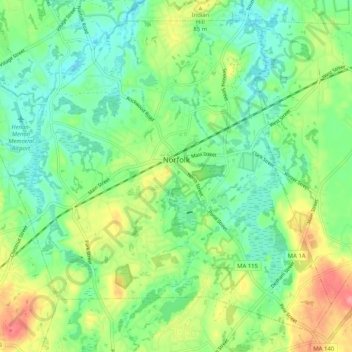
Name: Norfolk topographic map, elevation, terrain.
Location: Norfolk, Norfolk County, Massachusetts, 02056, United States (42.08239 -71.38217 42.14950 -71.28027)
Average elevation: 210 ft
Minimum elevation: 108 ft
Maximum elevation: 397 ft
Norfolk County trails, hiking, mountain biking, running and outdoor activities
Make a donation
Gear up for your next adventure:
As an Amazon Associate, this site earns from qualifying purchases at no extra cost to you.
Other topographic maps
Click on a map to view its topography, its elevation and its terrain.
Make a donation
Gear up for your next adventure:
As an Amazon Associate, this site earns from qualifying purchases at no extra cost to you.
Make a donation
Gear up for your next adventure:
As an Amazon Associate, this site earns from qualifying purchases at no extra cost to you.
Braintree Highlands
United States > Massachusetts > Norfolk County > Braintree
Average elevation: 151 ft
Randolph
United States > Massachusetts > Norfolk County > Randolph > Randolph
Average elevation: 190 ft
Make a donation
Gear up for your next adventure:
As an Amazon Associate, this site earns from qualifying purchases at no extra cost to you.
Make a donation
Gear up for your next adventure:
As an Amazon Associate, this site earns from qualifying purchases at no extra cost to you.
Make a donation
Gear up for your next adventure:
As an Amazon Associate, this site earns from qualifying purchases at no extra cost to you.
Braintree
United States > Massachusetts > Norfolk County > Braintree > Braintree
Average elevation: 128 ft
City Mills
United States > Massachusetts > Norfolk County > Norfolk > City Mills
Average elevation: 217 ft
Make a donation
Gear up for your next adventure:
As an Amazon Associate, this site earns from qualifying purchases at no extra cost to you.