
Make a donation
Gear up for your next adventure:
As an Amazon Associate, this site earns from qualifying purchases at no extra cost to you.
Alto Vista topographic map
Click on the map to display elevation.
Make a donation
Gear up for your next adventure:
As an Amazon Associate, this site earns from qualifying purchases at no extra cost to you.
About this map
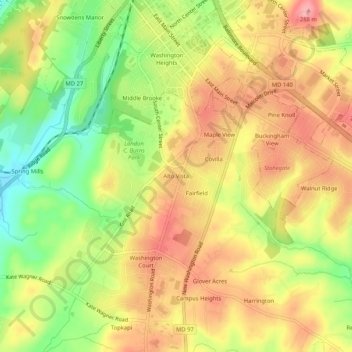
Name: Alto Vista topographic map, elevation, terrain.
Location: Alto Vista, Carroll County, Maryland, 21157, United States (39.53427 -77.01026 39.57427 -76.97026)
Average elevation: 787 ft
Minimum elevation: 577 ft
Maximum elevation: 951 ft
Carroll County trails, hiking, mountain biking, running and outdoor activities
Make a donation
Gear up for your next adventure:
As an Amazon Associate, this site earns from qualifying purchases at no extra cost to you.
Other topographic maps
Click on a map to view its topography, its elevation and its terrain.
Avondale Wildlife Management Area
United States > Maryland > Carroll County > Chapel Heights
Average elevation: 676 ft
Make a donation
Gear up for your next adventure:
As an Amazon Associate, this site earns from qualifying purchases at no extra cost to you.