Geolocate

Chavassery topographic map

Click on the map to display elevation.

About this map

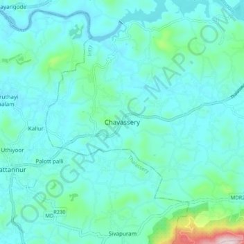
Name: Chavassery topographic map, elevation, terrain.

Location: Chavassery, Iritty, Kannur District, Kerala, 670702, India (11.90638 75.56908 11.98638 75.64908)

Average elevation: 233 ft

Minimum elevation: 20 ft

Maximum elevation: 1,575 ft

Other topographic maps

Click on a map to view its topography, its elevation and its terrain.

Ulikkal

India > Kerala > Iritty > Nuchiyad

Average elevation: 528 ft

Iritty

India > Kerala > Iritty

Average elevation: 213 ft

Kottiyoor

India > Kerala > Iritty > Ambayathode

Average elevation: 1,293 ft

Aralam

India > Kerala > Iritty > Iritty

Average elevation: 282 ft

Kelakam

India > Kerala > Iritty > Adakkathodu

Average elevation: 1,063 ft

Aralam WLS

India > Kerala > Iritty > Adakkathodu

Average elevation: 1,516 ft

Gear up for your next adventure:

🏫Relief Map Kits - Hands-on tools for teaching landforms and elevation
🚁Photography Drones - Capture stunning aerial views of landforms and topography
😴Insulated Sleeping Pads - Compact and warm pads for high-elevation camping
📶Satellite Messenger - Communication device off‑grid
🔪Outdoor Multitools - Essential survival tools for gear repair and field use

As an Amazon Associate, this site earns from qualifying purchases at no extra cost to you.