Geolocate

Wickliffe topographic map

Click on the map to display elevation.

About this map

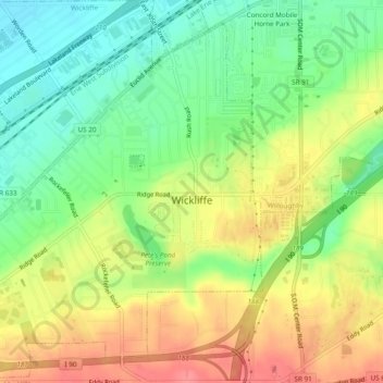
Name: Wickliffe topographic map, elevation, terrain.

Location: Wickliffe, Lake County, Ohio, 44092, United States (41.58825 -81.48869 41.62402 -81.44457)

Average elevation: 741 ft

Minimum elevation: 627 ft

Maximum elevation: 866 ft

Lake County trails, hiking, mountain biking, running and outdoor activities

Other topographic maps

Click on a map to view its topography, its elevation and its terrain.

Waite Hill

United States > Ohio > Lake County > Waite Hill

Average elevation: 738 ft

Mentor

United States > Ohio > Lake County > Mentor > Mentor

Average elevation: 794 ft

South Madison

United States > Ohio > Lake County

Average elevation: 919 ft

Painesville

United States > Ohio > Lake County > Painesville > Painesville

Average elevation: 666 ft

Gildersleeve Mountain

United States > Ohio > Lake County > Kirtland

Average elevation: 991 ft

Gear up for your next adventure:

🚪Portable Camp Chair - Foldable chair for comfort at camp
🎒Hydration Pack - Hands‑free water reservoir for long hikes
🗃️Trail First Aid Kit - Essential kit for outdoor injuries and emergencies
🥄Camping Utensil Set - Lightweight utensils for outdoor meals
🛏️Cold Weather Sleeping Bag - Warm sleeping bag for cold conditions

As an Amazon Associate, this site earns from qualifying purchases at no extra cost to you.