Geolocate

South Madison topographic map

Click on the map to display elevation.

About this map

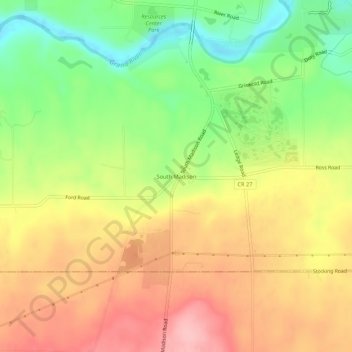
Name: South Madison topographic map, elevation, terrain.

Location: South Madison, Lake County, Ohio, United States (41.70533 -81.07010 41.74533 -81.03010)

Average elevation: 919 ft

Minimum elevation: 673 ft

Maximum elevation: 1,148 ft

Lake County trails, hiking, mountain biking, running and outdoor activities

Other topographic maps

Click on a map to view its topography, its elevation and its terrain.

Fairport Harbor

United States > Ohio > Lake County

Average elevation: 597 ft

Wickliffe

United States > Ohio > Lake County

Average elevation: 741 ft

Grand River

United States > Ohio > Lake County

Average elevation: 597 ft

Painesville

United States > Ohio > Lake County

Average elevation: 656 ft

Kirtland Hills

United States > Ohio > Lake County

Average elevation: 886 ft

Willowick

United States > Ohio > Lake County

Average elevation: 617 ft

Gear up for your next adventure:

🧭Orienteering Set - Complete compass and map reading kit
Backpacking Tent - Lightweight and durable tent for multi‑day hikes
🍳Camping Cook Set - Complete cookware for outdoor meals
😴Insulated Sleeping Pads - Compact and warm pads for high-elevation camping
🧭Hiking Compass - Precision compass for reliable navigation in the wilderness

As an Amazon Associate, this site earns from qualifying purchases at no extra cost to you.