Geolocate

Middlebourne topographic map

Click on the map to display elevation.

About this map

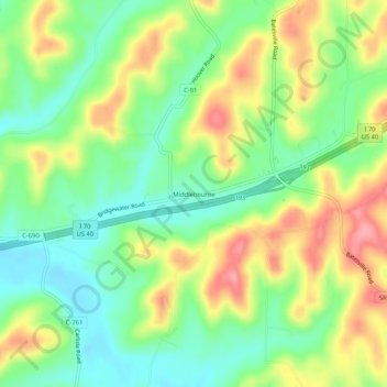
Name: Middlebourne topographic map, elevation, terrain.

Location: Middlebourne, Guernsey County, Ohio, United States (40.03118 -81.35650 40.07118 -81.31650)

Average elevation: 945 ft

Minimum elevation: 804 ft

Maximum elevation: 1,135 ft

Guernsey County trails, hiking, mountain biking, running and outdoor activities

Other topographic maps

Click on a map to view its topography, its elevation and its terrain.

Byesville

United States > Ohio > Guernsey County

Average elevation: 860 ft

Fairview

United States > Ohio > Guernsey County

Average elevation: 1,132 ft

Lore City

United States > Ohio > Guernsey County

Average elevation: 869 ft

Cumberland

United States > Ohio > Guernsey County

Average elevation: 902 ft

Gear up for your next adventure:

📱Solar Portable Charger - Solar power bank for charging devices off‑grid
📌Outdoor GPS Map App - Apps and devices for digital topographic navigation
🪑Portable Camp Table - Compact table for campsite meals
🔥Plasma Lighters - Windproof lighters that work in any weather condition
🌲Outdoor Survival Books - Best books on survival skills

As an Amazon Associate, this site earns from qualifying purchases at no extra cost to you.