Geolocate

Deep Ellum PID topographic map

Click on the map to display elevation.

Deep Ellum PID

Following World War II, the success of Deep Ellum started to fade. The ever-growing availability and use of the automobile led to the removal of the Houston and Texas Central railroad tracks—to make way for Central Expressway—and by 1956 the streetcar line had been removed. Businesses closed, residents moved to the suburbs and the music all but stopped. In 1969, a new elevation of Central Expressway truncated Deep Ellum, completely obliterating the 2400 block of Elm Street, viewed by many as the center of the neighborhood. By the 1970s, few original businesses remained.

Wikipedia (CC-BY-SA 3.0)

About this map

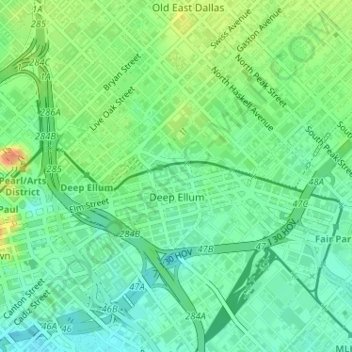
Name: Deep Ellum PID topographic map, elevation, terrain.

Location: Deep Ellum PID, Dallas, Dallas County, Texas, United States (32.78030 -96.79177 32.79138 -96.76503)

Average elevation: 476 ft

Minimum elevation: 423 ft

Maximum elevation: 568 ft

Dallas County trails, hiking, mountain biking, running and outdoor activities

Other topographic maps

Click on a map to view its topography, its elevation and its terrain.

Oak Cliff

United States > Texas > Dallas County > Dallas > Oak Cliff

Average elevation: 499 ft

White Rock Lake

United States > Texas > Dallas County > Dallas

Average elevation: 499 ft

Audelia

United States > Texas > Dallas County > Dallas

Average elevation: 607 ft

West End Square

United States > Texas > Dallas County > Dallas

Average elevation: 440 ft

Flag Pole Hill Park

United States > Texas > Dallas County > Dallas

Average elevation: 515 ft

Lake Cliff Park

United States > Texas > Dallas County > Dallas

Average elevation: 469 ft

Stevens Park

United States > Texas > Dallas County > Dallas

Average elevation: 558 ft

Sargent

United States > Texas > Dallas County > Dallas

Average elevation: 443 ft

Cole

United States > Texas > Dallas County > Dallas

Average elevation: 640 ft

Joppa Preserve

United States > Texas > Dallas County > Dallas

Average elevation: 404 ft

Eagle Ford

United States > Texas > Dallas County > Dallas > Eagle Ford

Average elevation: 430 ft

Gear up for your next adventure:

🧥Men's Rain Shells - Premium waterproof and breathable jackets for mountain weather
🛠️Outdoor Gear Repair Kit - Essential tools to fix gear on the trail
🌧️Backpack Rain Cover - Keep gear dry in wet weather
🌄Hiking Binoculars - Compact binoculars for scenic views and trail spotting
🎒Trekking Poles - Sturdy poles for balance and stability on rough terrain

As an Amazon Associate, this site earns from qualifying purchases at no extra cost to you.