Geolocate

Momo topographic map

Click on the map to display elevation.

About this map

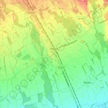
Name: Momo topographic map, elevation, terrain.

Location: Momo, Novara, Piemonte, 28015, Italia (45.54496 8.52620 45.59950 8.60046)

Average elevation: 692 ft

Minimum elevation: 623 ft

Maximum elevation: 778 ft

Other topographic maps

Click on a map to view its topography, its elevation and its terrain.

Sovazza

Italia > Piemonte > Novara

Average elevation: 2,238 ft

Gaggiolo

Italia > Piemonte > Novara

Average elevation: 692 ft

Gattico

Italia > Piemonte > Novara

Average elevation: 1,109 ft

Fosseno

Italia > Piemonte > Novara

Average elevation: 1,798 ft

Coiromonte

Italia > Piemonte > Novara

Average elevation: 2,425 ft

Tabarino

Italia > Piemonte > Novara

Average elevation: 1,821 ft

Gear up for your next adventure:

🧥Men's Rain Shells - Premium waterproof and breathable jackets for mountain weather
🥾Men's Hiking Boots - Durable, waterproof footwear for rugged terrain and steep inclines
🪶Trail Camera - Capture wildlife on your hikes
🔦LED Headlamp - Bright and durable LED headlamp for night navigation
🌎3D Topographic Globes - Raised relief globes for a tactile understanding of geography

As an Amazon Associate, this site earns from qualifying purchases at no extra cost to you.