Geolocate

Royerton topographic map

Click on the map to display elevation.

About this map

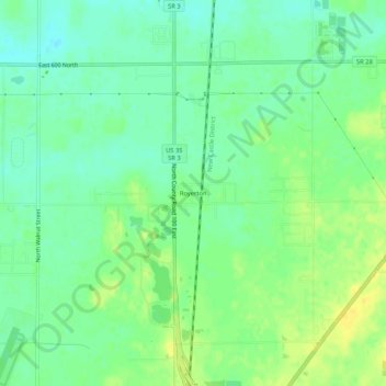
Name: Royerton topographic map, elevation, terrain.

Location: Royerton, Delaware County, Indiana, 47303, United States (40.24365 -85.38553 40.28365 -85.34553)

Average elevation: 935 ft

Minimum elevation: 899 ft

Maximum elevation: 978 ft

Delaware County trails, hiking, mountain biking, running and outdoor activities

Other topographic maps

Click on a map to view its topography, its elevation and its terrain.

Yorktown

United States > Indiana > Delaware County

Average elevation: 925 ft

Eaton

United States > Indiana > Delaware County

Average elevation: 915 ft

Albany

United States > Indiana > Delaware County

Average elevation: 951 ft

Daleville

United States > Indiana > Delaware County

Average elevation: 919 ft

Selma

United States > Indiana > Delaware County

Average elevation: 997 ft

White River

United States > Indiana > Delaware County > Yorktown

Average elevation: 925 ft

Gear up for your next adventure:

👟Men's Trail Runners - Lightweight footwear for fast-paced exploration and light hiking
🥘Titanium Cookware - Durable, featherlight pots and pans for backpacking
🎒Waterproof Dry Bags - Keep your electronics and maps dry inside your pack
📡Handheld GPS Device - Reliable handheld GPS for outdoor navigation
🪶Thermal Camp Blanket - Extra warmth for cold nights

As an Amazon Associate, this site earns from qualifying purchases at no extra cost to you.