Geolocate

Eaton topographic map

Click on the map to display elevation.

About this map

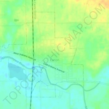
Name: Eaton topographic map, elevation, terrain.

Location: Eaton, Delaware County, Indiana, 47338, United States (40.33110 -85.37232 40.35220 -85.34136)

Average elevation: 915 ft

Minimum elevation: 876 ft

Maximum elevation: 968 ft

Delaware County trails, hiking, mountain biking, running and outdoor activities

Other topographic maps

Click on a map to view its topography, its elevation and its terrain.

Andersonville

United States > Indiana > Delaware County > Muncie

Average elevation: 942 ft

Cowan

United States > Indiana > Delaware County

Average elevation: 994 ft

Oakville

United States > Indiana > Delaware County

Average elevation: 1,014 ft

Royerton

United States > Indiana > Delaware County

Average elevation: 935 ft

White River

United States > Indiana > Delaware County > Yorktown

Average elevation: 925 ft

Creston

United States > Indiana > Delaware County > Muncie > Creston

Average elevation: 958 ft

Muncie

United States > Indiana > Delaware County > Muncie

Average elevation: 965 ft

Gear up for your next adventure:

🦺Reflective Outdoor Gear - Safety gear for low‑light conditions
GPS Sports Watch - GPS watch for running, hiking and training
🩹Survival Bandages - High‑quality bandages for emergencies
🎒Gear Packing Cubes - Organize your backpack efficiently
🥘Titanium Cookware - Durable, featherlight pots and pans for backpacking

As an Amazon Associate, this site earns from qualifying purchases at no extra cost to you.