Geolocate
👉 Easily get elevation data in JSON, GeoTIFF and KML formats using Elevation API
Thank you for supporting this site ❤️
Make a donation

Selma topographic map

Click on the map to display elevation.

About this map

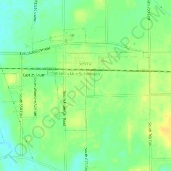
Name: Selma topographic map, elevation, terrain.

Location: Selma, Delaware County, Indiana, United States (40.17797 -85.29226 40.19731 -85.25442)

Average elevation: 997 ft

Minimum elevation: 958 ft

Maximum elevation: 1,033 ft

Delaware County trails, hiking, mountain biking, running and outdoor activities

Other topographic maps

Click on a map to view its topography, its elevation and its terrain.

Cowan

United States > Indiana > Delaware County

Average elevation: 994 ft

Oakville

United States > Indiana > Delaware County

Average elevation: 1,014 ft

Royerton

United States > Indiana > Delaware County

Average elevation: 935 ft

Andersonville

United States > Indiana > Delaware County > Muncie

Average elevation: 942 ft

Muncie

United States > Indiana > Delaware County > Muncie

Average elevation: 965 ft

White River

United States > Indiana > Delaware County > Yorktown

Average elevation: 925 ft

Creston

United States > Indiana > Delaware County > Muncie > Creston

Average elevation: 958 ft

Gear up for your next adventure:

📻Weather Alert Radios - Stay informed of storm risks while off-the-grid
🛠️Outdoor Gear Repair Kit - Essential tools to fix gear on the trail
🔋Solar Power Banks - Keep your GPS and phone charged in remote wilderness areas
🎒Hydration Pack - Hands‑free water reservoir for long hikes
🧤Hiking Gloves - Protective gloves for rugged trails

As an Amazon Associate, this site earns from qualifying purchases at no extra cost to you.