Geolocate

Cullman topographic map

Click on the map to display elevation.

Cullman

Cullman is located on top of the Brindley Mountain plateau at 34°10′39″N 86°50′42″W / 34.17750°N 86.84500°W / 34.17750; -86.84500 (34.177508, −86.844996). This is a close offshoot of the long geographic ridge called Sand Mountain, a southmost extension of the Appalachian Mountains. The elevation is 826 feet (252 m), close to the watershed between the Tennessee River and the Black Warrior River. Cullman provides its own town water supply from a city-owned lake within the city limits, Lake Catoma.

Wikipedia (CC-BY-SA 3.0)

About this map

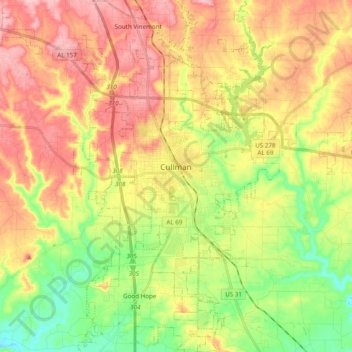
Name: Cullman topographic map, elevation, terrain.

Location: Cullman, Cullman County, Alabama, United States (34.09015 -86.90025 34.25071 -86.77715)

Average elevation: 784 ft

Minimum elevation: 522 ft

Maximum elevation: 1,053 ft

Cullman County trails, hiking, mountain biking, running and outdoor activities

Other topographic maps

Click on a map to view its topography, its elevation and its terrain.

Vinemont

United States > Alabama > Cullman County > South Vinemont

Average elevation: 948 ft

Logan

United States > Alabama > Cullman County

Average elevation: 787 ft

Bremen

United States > Alabama > Cullman County

Average elevation: 653 ft

Black Bottom

United States > Alabama > Cullman County

Average elevation: 381 ft

Birdsong

United States > Alabama > Cullman County

Average elevation: 876 ft

Battleground

United States > Alabama > Cullman County

Average elevation: 991 ft

East Point

United States > Alabama > Cullman County

Average elevation: 755 ft

Joppa

United States > Alabama > Cullman County

Average elevation: 1,010 ft

Smithdale

United States > Alabama > Cullman County > Cullman

Average elevation: 879 ft

Ardell

United States > Alabama > Cullman County

Average elevation: 577 ft

Providence

United States > Alabama > Cullman County

Average elevation: 932 ft

Trade

United States > Alabama > Cullman County

Average elevation: 689 ft

Jones Chapel

United States > Alabama > Cullman County

Average elevation: 869 ft

Good Hope

United States > Alabama > Cullman County > Good Hope

Average elevation: 689 ft

Gear up for your next adventure:

🌄Hiking Binoculars - Compact binoculars for scenic views and trail spotting
🛡️Bear Spray Outdoor - Protection in bear country hikes
🗺️NatGeo Topo Maps - High-quality waterproof printed topographic maps of US Parks
📷Action Cameras - Rugged cameras to document your journeys across rugged terrain
🪶Compact Camp Shovel - Folding shovel for campsite tasks

As an Amazon Associate, this site earns from qualifying purchases at no extra cost to you.