
Make a donation
Gear up for your next adventure:
As an Amazon Associate, this site earns from qualifying purchases at no extra cost to you.
Logan topographic map
Click on the map to display elevation.
Make a donation
Gear up for your next adventure:
As an Amazon Associate, this site earns from qualifying purchases at no extra cost to you.
About this map
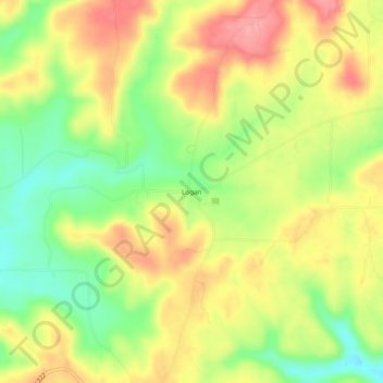
Name: Logan topographic map, elevation, terrain.
Location: Logan, Cullman County, Alabama, 35098, United States (34.11816 -87.02639 34.15816 -86.98639)
Average elevation: 787 ft
Minimum elevation: 614 ft
Maximum elevation: 945 ft
Cullman County trails, hiking, mountain biking, running and outdoor activities
Make a donation
Gear up for your next adventure:
As an Amazon Associate, this site earns from qualifying purchases at no extra cost to you.
Other topographic maps
Click on a map to view its topography, its elevation and its terrain.
Holly Pond
United States > Alabama > Cullman County
Holly Pond is located in eastern Cullman County at 34°10′29″N 86°37′1″W / 34.17472°N 86.61694°W / 34.17472; -86.61694 (34.174657, -86.617004). The town is concentrated around the intersection of U.S. Route 278 and State Route 91. The elevation at the center of town is approximately 870…
Average elevation: 817 ft
Make a donation
Gear up for your next adventure:
As an Amazon Associate, this site earns from qualifying purchases at no extra cost to you.
Dodge City
United States > Alabama > Cullman County
The elevation is 628 feet (191 m) above sea level.
Average elevation: 630 ft
Cullman
United States > Alabama > Cullman County
Cullman is located on top of the Brindley Mountain plateau at 34°10′39″N 86°50′42″W / 34.17750°N 86.84500°W / 34.17750; -86.84500 (34.177508, −86.844996). This is a close offshoot of the long geographic ridge called Sand Mountain, a southmost extension of the Appalachian Mountains. The…
Average elevation: 784 ft
Make a donation
Gear up for your next adventure:
As an Amazon Associate, this site earns from qualifying purchases at no extra cost to you.