
Lawton topographic map
Click on the map to display elevation.
Lawton
Developed on former reservation lands of the Kiowa, Comanche, and Apache Indians, Lawton was founded by European Americans on 6 August 1901. It was named after Major General Henry Ware Lawton, who served in the Civil War, where he earned the Medal of Honor, and was killed in action in the Philippine–American War. Lawton's landscape is typical of the Great Plains, with flat topography and gently rolling hills, while the area north of the city is marked by the Wichita Mountains.
About this map
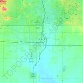
Name: Lawton topographic map, elevation, terrain.
Location: Lawton, Comanche County, Oklahoma, United States (34.51150 -98.53649 34.69435 -98.31443)
Average elevation: 1,155 ft
Minimum elevation: 1,030 ft
Maximum elevation: 1,722 ft
Comanche County trails, hiking, mountain biking, running and outdoor activities
Other topographic maps
Click on a map to view its topography, its elevation and its terrain.
Wichita Mountains Wildlife Refuge
United States > Oklahoma > Comanche County
Average elevation: 1,942 ft
Medicine Bluffs
United States > Oklahoma > Comanche County > Lawton > White Wolf Bridge
Average elevation: 1,191 ft
South East Corner Landing Strip
United States > Oklahoma > Comanche County
Average elevation: 1,257 ft