
Pune topographic map
Interactive map
Click on the map to display elevation.
Pune
Pune lies on the western margin of the Deccan plateau, at an altitude of 560 m (1,840 ft) above sea level. It is on the leeward side of the Sahyadri mountain range, which forms a barrier from the Arabian Sea. It is a hilly city, with Vetal Hill rising to 800 m (2,600 ft) above sea level. The Sinhagad fort is at an altitude of 1,300 metres (4,300 feet).
About this map
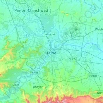
Name: Pune topographic map, elevation, terrain.
Location: Pune, Pune District, Maharashtra, India (18.42950 73.74985 18.62087 74.02021)
Average elevation: 2,021 ft
Minimum elevation: 1,736 ft
Maximum elevation: 3,734 ft
Other topographic maps
Click on a map to view its topography, its elevation and its terrain.
Navi Mumbai
India > Maharashtra > Thane > Navi Mumbai
Navi Mumbai (Marathi pronunciation: , also known by its former name New Bombay), is a planned city off the west coast of the Indian state of Maharashtra in Konkan division. The city is divided into two parts, North Navi Mumbai and South Navi Mumbai, for the individual development of Panvel Mega City, which…
Average elevation: 98 ft
Lonavala
India > Maharashtra > Mawal
Adjacent to the Lohagad fort lies the visapur fort which is part of the Lohagad-Visapur fortification. Visapur Fort is larger and at a higher elevation than its twin- Lohagad. It was built during 1713-1720 CE by Balaji Vishwanath.
Average elevation: 2,011 ft
Satara
India > Maharashtra > Satara
Satara city has a tropical wet and dry climate (Köppen climate classification: Aw) that is influenced by the relatively high altitude and mountains surrounding the city. Summers are more hot than the winters. Satara city receives rainfall from 900 mm to 1,500 mm depending on the strength of the monsoon.
Average elevation: 2,454 ft
Panvel
India > Maharashtra > Panvel > Panvel
Matheran is a hill station and a municipal council in the Raigad district in the Indian state of Maharashtra. It is a hill station in Karjat Tahsil and is also the smallest hill station in India. It is located on the Western Ghats range at an elevation of around 800 m (2,625 feet) above sea level. It is…
Average elevation: 246 ft
Savda
India > Maharashtra > Raver
Savda is located at 21°09′N 75°53′E / 21.15°N 75.88°E / 21.15; 75.88. It has an average elevation of 231 metres (757 feet).
Average elevation: 735 ft
Jejuri
India > Maharashtra > Purandhar
Jejuri is located at 18°17′N 74°10′E / 18.28°N 74.17°E / 18.28; 74.17. It has an average elevation of 718 metres (2355 feet) mean sea level.
Average elevation: 2,388 ft
Akole
India > Maharashtra > Akola
Kalsubai is the highest peak in Maharashtra, with an elevation of 1,646 meters (5,400 feet). Ghatghar, located 22 kilometers (14 miles) from Bhandardara, offers views of the Sahyadri range and is the site of the Udanchan Hydro-power project's first installation, which has a capacity of 250 MW. Additionally,…
Average elevation: 2,457 ft
Uran
India > Maharashtra > Uran Taluka
Uran is located at 18°53′N 72°56′E / 18.88°N 72.94°E / 18.88; 72.94. Uran is at an average elevation of 21 metres (69 ft).
Average elevation: 33 ft
Solapur
India > Maharashtra > Solapur North
Solapur is located at 17°41′N 75°55′E / 17.68°N 75.92°E / 17.68; 75.92. It has an average elevation of 458 metres (1502 feet). It is bordered by Ahmednagar district on the north; Osmanabad district on the north and northeast.
Average elevation: 1,539 ft
Dahanu
India > Maharashtra > Dahanu Taluka
Dahanu is located at 19°58′N 72°44′E / 19.97°N 72.73°E / 19.97; 72.73. It has an average elevation of 9.89 metres. To the west of the town is the coast of the Arabian Sea while the east is lined with the Sahyadri ranges. This combination has made Dahanu a tourist destination. Sprawling Chickoo…
Average elevation: 30 ft