
Make a donation
Gear up for your next adventure:
As an Amazon Associate, this site earns from qualifying purchases at no extra cost to you.
Little Berkhamsted topographic map
Click on the map to display elevation.
Make a donation
Gear up for your next adventure:
As an Amazon Associate, this site earns from qualifying purchases at no extra cost to you.
About this map
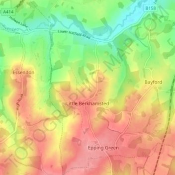
Name: Little Berkhamsted topographic map, elevation, terrain.
Average elevation: 289 ft
Minimum elevation: 131 ft
Maximum elevation: 423 ft
Make a donation
Gear up for your next adventure:
As an Amazon Associate, this site earns from qualifying purchases at no extra cost to you.
Other topographic maps
Click on a map to view its topography, its elevation and its terrain.
Spellbrook
United Kingdom > England > Hertfordshire > East Hertfordshire > Sawbridgeworth
Average elevation: 233 ft
Hertingfordbury
United Kingdom > England > Hertfordshire > East Hertfordshire
Average elevation: 200 ft
Make a donation
Gear up for your next adventure:
As an Amazon Associate, this site earns from qualifying purchases at no extra cost to you.
Astonbury Wood
United Kingdom > England > Hertfordshire > East Hertfordshire > Aston
Average elevation: 272 ft
Throcking
United Kingdom > England > Hertfordshire > East Hertfordshire > Buntingford
Average elevation: 413 ft
Make a donation
Gear up for your next adventure:
As an Amazon Associate, this site earns from qualifying purchases at no extra cost to you.
Tewin Wood
United Kingdom > England > Hertfordshire > East Hertfordshire > Burnham Green
Average elevation: 331 ft
Chapmore End
United Kingdom > England > Hertfordshire > East Hertfordshire > Tonwell
Average elevation: 213 ft
Make a donation
Gear up for your next adventure:
As an Amazon Associate, this site earns from qualifying purchases at no extra cost to you.
Stanstead St Margarets
United Kingdom > England > Hertfordshire > East Hertfordshire
Average elevation: 157 ft
Hadham Cross
United Kingdom > England > Hertfordshire > East Hertfordshire > Much Hadham
Average elevation: 259 ft
Thorley Street
United Kingdom > England > Hertfordshire > East Hertfordshire > Thorley
Average elevation: 243 ft
Make a donation
Gear up for your next adventure:
As an Amazon Associate, this site earns from qualifying purchases at no extra cost to you.
Whempstead
United Kingdom > England > Hertfordshire > East Hertfordshire > Dane End
Average elevation: 312 ft
Make a donation
Gear up for your next adventure:
As an Amazon Associate, this site earns from qualifying purchases at no extra cost to you.
Church End
United Kingdom > England > Hertfordshire > East Hertfordshire > Little Hadham
Average elevation: 312 ft
Crab's Green
United Kingdom > England > Hertfordshire > East Hertfordshire > Stocking Pelham
Average elevation: 364 ft
Watton-at-Stone
United Kingdom > England > Hertfordshire > East Hertfordshire
Average elevation: 282 ft
Make a donation
Gear up for your next adventure:
As an Amazon Associate, this site earns from qualifying purchases at no extra cost to you.
Cold Christmas
United Kingdom > England > Hertfordshire > East Hertfordshire
Average elevation: 236 ft
Baker's End
United Kingdom > England > Hertfordshire > East Hertfordshire > Wareside > Baker's End
Average elevation: 240 ft
Waterford
United Kingdom > England > Hertfordshire > East Hertfordshire > Waterford
Average elevation: 217 ft
Make a donation
Gear up for your next adventure:
As an Amazon Associate, this site earns from qualifying purchases at no extra cost to you.
Hare Street
United Kingdom > England > Hertfordshire > East Hertfordshire > Great Hormead
Average elevation: 361 ft
Hertford Heath Nature Reserve
United Kingdom > England > Hertfordshire > East Hertfordshire > Hertford Heath
Average elevation: 259 ft
Painter's Green
United Kingdom > England > Hertfordshire > East Hertfordshire > Datchworth
Average elevation: 328 ft
Dassels
United Kingdom > England > Hertfordshire > East Hertfordshire > Dassels
Average elevation: 341 ft
Make a donation
Gear up for your next adventure:
As an Amazon Associate, this site earns from qualifying purchases at no extra cost to you.
Moor Green
United Kingdom > England > Hertfordshire > East Hertfordshire > Ardeley
Average elevation: 404 ft
Tewin Wood
United Kingdom > England > Hertfordshire > East Hertfordshire > Burnham Green
Average elevation: 331 ft
Hertford Lock No 1
United Kingdom > England > Hertfordshire > East Hertfordshire > Hertford
Average elevation: 174 ft
Make a donation
Gear up for your next adventure:
As an Amazon Associate, this site earns from qualifying purchases at no extra cost to you.
Cold Christmas
United Kingdom > England > Hertfordshire > East Hertfordshire
Average elevation: 236 ft
Broad Green
United Kingdom > England > Hertfordshire > East Hertfordshire > Bayford
Average elevation: 240 ft