
Make a donation
Gear up for your next adventure:
As an Amazon Associate, this site earns from qualifying purchases at no extra cost to you.
Stanstead St Margarets topographic map
Click on the map to display elevation.
Make a donation
Gear up for your next adventure:
As an Amazon Associate, this site earns from qualifying purchases at no extra cost to you.
About this map
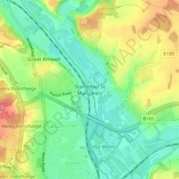
Name: Stanstead St Margarets topographic map, elevation, terrain.
Average elevation: 157 ft
Minimum elevation: 69 ft
Maximum elevation: 302 ft
Make a donation
Gear up for your next adventure:
As an Amazon Associate, this site earns from qualifying purchases at no extra cost to you.
Other topographic maps
Click on a map to view its topography, its elevation and its terrain.
Astonbury Wood
United Kingdom > England > Hertfordshire > East Hertfordshire > Aston
Average elevation: 272 ft
Bishop's Stortford
United Kingdom > England > Hertfordshire > East Hertfordshire
Stortford, along with the rest of Britain, has a temperate maritime climate, with cool summers and mild winters. The nearest weather station for which averages and extremes are available is Stansted Airport, about 2+1⁄2 miles (4 kilometres) due east of Stortford's town centre. Located at an elevation of over…
Average elevation: 272 ft
Make a donation
Gear up for your next adventure:
As an Amazon Associate, this site earns from qualifying purchases at no extra cost to you.
Make a donation
Gear up for your next adventure:
As an Amazon Associate, this site earns from qualifying purchases at no extra cost to you.
King's Meads
United Kingdom > England > Hertfordshire > East Hertfordshire > Ware
Average elevation: 174 ft
Furneux Pelham
United Kingdom > England > Hertfordshire > East Hertfordshire > Furneux Pelham
Average elevation: 371 ft
Thundridge
United Kingdom > England > Hertfordshire > East Hertfordshire > High Cross
Average elevation: 256 ft
Make a donation
Gear up for your next adventure:
As an Amazon Associate, this site earns from qualifying purchases at no extra cost to you.
Stocking Pelham
United Kingdom > England > Hertfordshire > East Hertfordshire > Stocking Pelham
Average elevation: 374 ft
Little Berkhamsted
United Kingdom > England > Hertfordshire > East Hertfordshire
Average elevation: 289 ft
Datchworth
United Kingdom > England > Hertfordshire > East Hertfordshire > Datchworth
Average elevation: 335 ft
Make a donation
Gear up for your next adventure:
As an Amazon Associate, this site earns from qualifying purchases at no extra cost to you.
Thorley
United Kingdom > England > Hertfordshire > East Hertfordshire > Thorley
Average elevation: 269 ft
Sawbridgeworth
United Kingdom > England > Hertfordshire > East Hertfordshire > Sawbridgeworth
Average elevation: 220 ft
Make a donation
Gear up for your next adventure:
As an Amazon Associate, this site earns from qualifying purchases at no extra cost to you.
Buntingford
United Kingdom > England > Hertfordshire > East Hertfordshire > Buntingford
Average elevation: 361 ft
Widford
United Kingdom > England > Hertfordshire > East Hertfordshire > Widford
Average elevation: 240 ft
Make a donation
Gear up for your next adventure:
As an Amazon Associate, this site earns from qualifying purchases at no extra cost to you.
Hertford Heath Nature Reserve
United Kingdom > England > Hertfordshire > East Hertfordshire > Hertford Heath
Average elevation: 259 ft
Hertingfordbury
United Kingdom > England > Hertfordshire > East Hertfordshire
Average elevation: 223 ft
Hertford Heath
United Kingdom > England > Hertfordshire > East Hertfordshire
Average elevation: 243 ft
Make a donation
Gear up for your next adventure:
As an Amazon Associate, this site earns from qualifying purchases at no extra cost to you.
Hertford Lock No 1
United Kingdom > England > Hertfordshire > East Hertfordshire > Hertford
Average elevation: 174 ft
Stocking Pelham
United Kingdom > England > Hertfordshire > East Hertfordshire
Average elevation: 374 ft
Braughing
United Kingdom > England > Hertfordshire > East Hertfordshire > Braughing
Average elevation: 341 ft
Make a donation
Gear up for your next adventure:
As an Amazon Associate, this site earns from qualifying purchases at no extra cost to you.
Sawbridgeworth
United Kingdom > England > Hertfordshire > East Hertfordshire > Sawbridgeworth
Average elevation: 220 ft
Buntingford
United Kingdom > England > Hertfordshire > East Hertfordshire > Buntingford
Average elevation: 361 ft